
Chleb, Veľký Kriváň and Malý Kriváň - loop in Malá Fatra from Vrátna Valley
This article will probably have more photos than text, because there is no other way to describe this route and its views than to simply show them to you. The variant we chose is not the easiest one because of its length and the large total elevation gain, but technically it is not particularly demanding, so you can easily adjust it to your abilities and mood.
We will show you what the route to Veľký Kriváň looks like, how many kilometres and metres of ascent it has, where to park and what the options for reaching the summit are. We will also tell you whether you can take the cable car up to Veľký Kriváň, whether the trail is difficult and what the alternative route variants are. We are giving you several options - pick the one that suits you best. And now, let's go!
Table of contents:
The Malá Fatra range
Malá Fatra is one of the most interesting mountain ranges in Slovakia, located in the north-western part of the country, in the Western Carpathians. Although it does not match the Tatras in height, it can impress with equally varied landscapes: vast mountain meadows, scenic ridges, rocky peaks, deep valleys, gorges and numerous waterfalls.
The highest peak of the entire Malá Fatra is Veľký Kriváň (1709 m), which lies on the main, very scenic ridge of the range. Nearby you will also find Malý Kriváň (1671 m) and Chleb (1646 m). The most characteristic peak of Malá Fatra, on the other hand, is Veľký Rozsutec (1610 m), whose rocky silhouette is one of the symbols of the region. Malá Fatra is also known for its more demanding and varied trails. Among the best-known attractions are Jánošíkove Diery, a system of rocky gorges with boardwalks, ladders and waterfalls, as well as Šútovský vodopád, the highest waterfall in Malá Fatra at around 38 metres.
The range is about 52 km long and up to 16-17 km wide. It is divided into two parts: Malá Fatra Krivánska and Malá Fatra Lúčanska, separated by the valley of the Váh river. The Krivánska part is the higher one and more popular among hikers. The variety of the landscape is what makes Malá Fatra such an interesting destination for a mountain trip. Walking along the ridge, you can go from forested slopes through vast meadows all the way to rocky summit sections in a single day. The main ridge of Malá Fatra Krivánska is especially impressive - in good weather it offers wide panoramas of the surrounding ranges.
A large part of this section of the mountains is protected within the Malá Fatra National Park, established in 1988. The park covers about 226 km² and stands out for its natural richness. You will find here, among others, extensive beech and spruce forests, high mountain meadows and many valuable species of plants and animals (including the one most associated with this region - bears, as we saw with our own eyes)
Veľký Kriváň
Veľký Kriváň (1709 m) is the highest peak of Malá Fatra and one of the best viewpoints in the whole range. It lies on the main ridge of Malá Fatra Krivánska, between Pekelník (1609 m) and Snilovské sedlo (where the cable car arrives), which separates it from the Chleb summit.
The summit itself is relatively gentle and grassy, and its surroundings show the character of this part of Malá Fatra well - broad meadows alternate with dwarf pine, and lower down forests appear. In good visibility you can see almost all of Malá Fatra, including Chleb, Malý Kriváň, Stoh and the characteristic silhouettes of Veľký and Malý Rozsutec. Further away you can also spot the Żywiec Beskids with Babia Góra and Wielka Racza, Veľký Choč, Veľká Fatra, the Low Tatras and the Tatras.
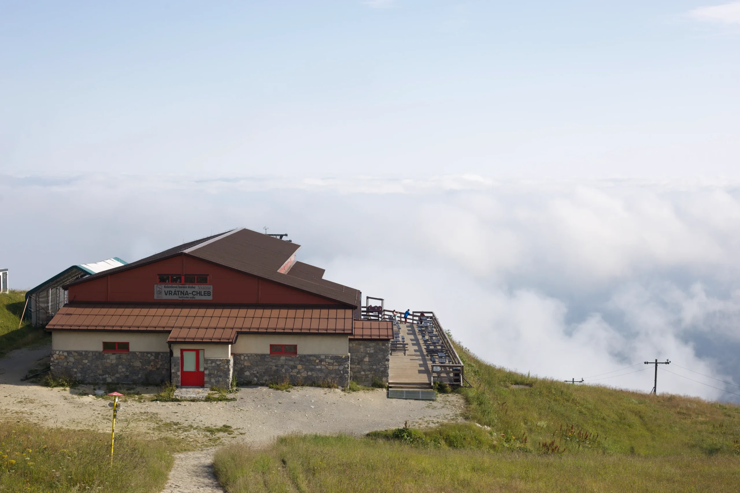
Veľký Kriváň can be reached from several directions, among others from Vrátna Dolina, a popular starting point near Terchová, and also from Turany. The easiest way to reach the summit is to take the gondola from Vrátna to Snilovské sedlo. From there, a relatively short and scenic ridge section leads to the top.
If you do not want to use the cable car, you can of course walk up from Vrátna. There are several variants, so Veľký Kriváň can be treated both as the goal of a shorter trip and as one of the points of a longer hike along the main ridge of Malá Fatra. We will present a few of them in this article.
There is also a tourist stamp at the summit, so if you collect souvenir stamps from the places you visit, it is worth bringing a stamp book or a notebook.
Parking
We left the car at the main paid car park by the cable car in Vrátna Dolina near Terchová. There are also several smaller car parks along the road leading to the cable car, so in high season it is worth arriving early, especially if you want to park as close to the trailhead as possible. Head for these coordinates: 49.209033, 19.041624. Parking costs 10 € for the whole day. You can also reach the start of the trail by public transport, as there is a bus stop here.
Route variants
Several trails lead to Veľký Kriváň, so you can adjust the trip both to the time you have and to how long a route you want to walk. We will present the ones starting from Vrátna Dolina, near Terchová. There are also several options for the ascent from the Turany side.
Trail to Chleb, Veľký Kriváň, Malý Kriváň - the variant described below
Veľký Kriváň trail - a loop
The green trail to Veľký Kriváň - the shortest variant
Cable car variant - Chleb - Veľký Kriváň - Malý Kriváň - with the cable car up to Snilovské sedlo
The trail over Chleb, Veľký Kriváň, Malý Kriváň
This is a long loop over as many as three peaks - Chleb, Veľký Kriváň and Malý Kriváň. Because of the length of the route and the large total elevation gain, we recommend it above all to more experienced hikers. It is not a technically demanding trail though - its difficulty comes mainly from the distance and the ascent. The climb at the start of the route is quite steep and can tire you out right away. Later, moving between the individual peaks is far more pleasant, and the trail, which runs along an open ridge the whole time, guarantees truly wonderful views. We also happened to catch the moment when clouds began to settle between the peaks, giving the whole route a unique atmosphere.
If you are looking for a shorter and easier option, it is worth having a look at the other variants as well - they also offer beautiful views and are more accessible.
- Trail length:
- 17,3 km
- Duration:
- 7:32 h
- Elevation gain:
- 1500 m
- Difficulty level:
- medium
The intermediate level comes from the length and the amount of ascent of the trail, not from technical difficulties. The trail itself is not demanding and, apart from fitness, no greater experience is needed.
Trail description
We start from the cable car base station in Vrátna, from where we set off along the green trail. The route climbs steeply straight away. Sometimes it follows a wider forest path, and at times it leaves the forest and runs directly under the cable car. The trail is mostly earthy with few rocky sections, which makes the ascent quite pleasant, although it definitely cannot be called easy. The first 3 km of the route mean as much as 737 m of ascent, so the trail climbs almost without a break. Along the way you will find one bench where you can rest for a moment.
In summer the path running under the cable car looks truly charming. It is surrounded by flowering meadows, and along the way you can find bilberries and, in places, wild strawberries and raspberries. This section took us about an hour. That is when the cable car building appeared before our eyes and we came out above the clouds, onto completely open terrain with beautiful mountain panoramas.
On the spur of the moment we decided to visit an additional, neighbouring peak - Chleb. The cable car had not started running yet, so passing only a handful of hikers we set off along the red trail towards the summit. From this point the route runs across open terrain the whole time, with little shade, provided only by the taller patches of dwarf pine. Do not let that open space fool you, though. To our surprise, a bear can surprise you here as well. Usually, when there is more traffic on the trail, the local residents go down to the lower parts of the mountains and hide in the forests. At the hour we appeared in this part of Malá Fatra, one of the bears was still around.
After meeting our brown friend, we climbed up to Chleb (1646 m) without any major adventures, and from there we had a beautiful view of Hromové, partly covered by an "avalanche of clouds". The ascent took us a bit longer because of the many photo stops. On the Turany side the views were hidden under a huge carpet of clouds, which created a truly unique atmosphere!
A moment to enjoy the views and we head back towards the cable car, and then onto the trail leading to the second peak - the highest in the entire Malá Fatra range. We reach the junction again and climb the red trail up to Veľký Kriváň. This section is fairly steep, but fortunately not too long. After less than 200 metres of ascent we reach the highest point of Malá Fatra. We do not stay at the summit for long, though, because tiny flying ants are giving us a hard time. So we go a little lower to eat our second breakfast in peace and head on towards Malý Kriváň.
From this point the trail along the ridge is much gentler and just as scenic. There are far fewer hikers heading towards Malý Kriváň, so most of the time we walk practically alone. After about 20 minutes we reach the junction at Sedlo Bublen, from where we follow the red trail towards our third and final peak.
The beginning of the climb turns out to be quite steep, and at first you cannot even see where it ends. If you get through this part, though, the trail clearly eases off later, and between the successive climbs the peak we are heading for starts to appear. Along the way there is one short section where you have to use your hands for a moment, but apart from that the route does not require any special technical skills. The trail is fairly narrow and runs across open terrain the whole time, with little shade. Instead, we are accompanied by grasses and beautifully blooming mountain flowers. This section also has the only water point on our route. We do not have reliable information on whether it is drinkable, though, so we treated it above all as a chance to cool down. On a hot day it can be really useful. From the junction to the summit there are about 2.3 km of a very scenic and pleasant trail that rewards the earlier climb.
From Malý Kriváň we go back the same way to the junction, where we join the yellow and then the blue trail, heading for the descent via Sedlo za Kraviarskym. As the altitude gradually drops, the terrain becomes more and more densely forested. From this moment on, practically only the descent awaits us, and the open mountain landscapes are slowly replaced by an ever taller and denser forest. Through the trees we can still make out the characteristic, soaring Veľký Rozsutec, which stands out against the surrounding peaks.
We walk the last kilometres along a forest path until we reach a small bridge over a stream. That is a sign that we have just reached the main road leading towards the car park. After such an exhausting route we could not deny ourselves one more pleasure, so we cool our tired legs in the icy water of the stream and head towards our car.
A summary of our route
In our opinion this is one of the most charming loops in Malá Fatra that we have managed to walk, but at the same time one of the more demanding ones. Even though we like to get tired during mountain treks, the next time we walk this route we would consider using the cable car - either on the descent, to spare our knees on the fairly steep section, or on the ascent, to save more energy for a longer walk along the ridge.
We have to admit, though, that setting off early, before the cable car started running, had huge advantages. There were far fewer hikers on the trail, and we also got to see several amazing weather phenomena. And… to meet the wild residents of this area.
In the end, choose the variant that best suits your abilities and your mood. Veľký Kriváň can be reached in several ways, so there is no need to go for the longest route straight away. On our trip we covered a total of 17.42 km, with 1395 m of ascent, in 6 hours and 20 minutes.
Cable car from Vrátna Dolina
If you want to shorten the route and skip the steepest climb, leaving yourself a bit more energy for walking along the ridge, you can take the gondola cable car from Vrátna Dolina up to Snilovské sedlo (1524 m). In August 2026 an adult ticket costs 23 € one way or 25 € return when bought at the ticket office. Online the prices are slightly lower - 22 € and 24 € respectively (for an adult). The cable car runs in the summer season, but its operation depends on the weather, so it is worth checking the current information on the operator's website before you go. It usually runs from 8:30, with the last ride down at 18. Current information, reduced fares and tickets can be found at - eshop.vratna.sk
Safety on the trail
Malá Fatra is beautiful, but at times quite wild, so before setting off on the trail it is worth remembering a few basic rules.
Bears
This is definitely the most important thing we want to mention. Brown bears are permanent residents of Malá Fatra, and during our trip we had the chance to meet one of them on the trail. Interestingly, the encounter happened on open, high mountain terrain, so do not assume that a bear can only be met in the forest.
Take particular care in the early morning hours and in the evening, when there are fewer people on the trails. When setting off on a hike, even during the day it is worth attaching special bells to your backpack to signal your presence to animals. This is of course no guarantee that a bear will not appear, but it can reduce the risk of a sudden encounter. If you spot a bear during your hike, do not approach it and do not try to photograph it from close up. Stay calm, do not run, and increase the distance if possible.
Water and food
Apart from the restaurant in the cable car building, there is no mountain hut on the route we describe where you could restock, so when heading into the mountains take enough water and food with you. Especially in summer it is worth having a reserve, because a large part of the route runs across open terrain where shade is hard to find.
Sun protection
The open ridge sections are beautiful, but in summer they also mean a lot of sun exposure. It is worth bringing a high-SPF sunscreen, a hat and sunglasses. Do not forget to reapply the cream regularly, especially on longer treks. On this route you can be practically out of the shade for several hours.
Overnight stays
Nature protection rules apply within the Malá Fatra National Park, so you should not pitch a tent or arrange an overnight stay outside designated places on your own. If you are planning a night in the mountains, it is best to check whether you can camp by a mountain hut. The closest one to the described loop is the hut below Chleb.
Staying on the trails
Leaving the marked hiking trails is also forbidden within the park. Do not cut corners across the meadows and do not try to create your own paths. Sticking to the marked routes matters not only for safety reasons. It also helps protect the vegetation and the natural habitats within the park, and it does not disturb the wild residents of the area.
Veľký Kriváň trail - a loop
If you came to Malá Fatra to reach its highest peak, this route is for you. The number of kilometres is considerably smaller than in the loop presented above, but we still recommend making a detour to the equally spectacular Chleb, because the climb is not too hard and the views make up for the effort. Below we present the most classic version - the ascent by the shorter but steeper climb and the descent by a slightly longer yet gentler route via Pekelník.
- Trail length:
- 10,3 km
- Duration:
- 5:00 h
- Elevation gain:
- 1039 m
- Difficulty level:
- easy
The green trail to Veľký Kriváň - the shortest variant
The fastest, shortest, yet most brutal climb to Veľký Kriváň, zigzagging up alongside the cable car.
- Trail length:
- 8,3 km
- Duration:
- 3:38 h
- Elevation gain:
- 961 m
- Difficulty level:
- easy
Cable car variant - Chleb - Veľký Kriváň - Malý Kriváň
If you want to save your energy so that you can enjoy the mountain views and cover more kilometres on the open ridge, it is worth using the cable car - one way, the other way or both. Depending on your strength, your mood and your options, you can adjust your route. We described the cable car prices above, and here we leave you an example route variant that you can modify according to your own preferences.
- Trail length:
- 11,6 km
- Duration:
- 4:12 h
- Elevation gain:
- 801 m
- Difficulty level:
- easy
- + cable car
And which trail do you choose? Or maybe you have already reached Veľký Kriváň some other way? Let us know in the comments!
Frequently asked questions
How long is the loop over Chleb, Veľký Kriváň and Malý Kriváň?
The whole loop from Vrátna Dolina is 17.3 km long, with about 1500 m of total ascent, and takes roughly 7:32 h. We walked it in 6 hours and 20 minutes, with a result of 17.42 km and 1395 m of ascent. It is a variant for more experienced hikers, mainly because of the distance and the elevation gain.
Where to park before hiking up Veľký Kriváň?
It is best to leave the car at the main paid car park by the cable car in Vrátna Dolina near Terchová, at the coordinates 49.209033, 19.041624. It costs 10 € for the whole day. There are also several smaller car parks along the road to the cable car, and you can reach the spot by bus as well, since there is a stop here.
Can you take a cable car up to Veľký Kriváň?
Yes, a gondola cable car runs from Vrátna Dolina up to Snilovské sedlo (1524 m), and from there a short, scenic ridge section leads to the summit. In August 2026 an adult ticket costs 23 € one way and 25 € return when bought at the ticket office, and 22 € and 24 € respectively online.
Is the trail over Chleb, Veľký Kriváň and Malý Kriváň difficult?
The intermediate level comes from the length of the route and the total ascent, not from technical difficulties. The climb at the start is steep, and on the ascent to Malý Kriváň there is a short section where you have to use your hands. Apart from that, the route does not require much experience, only fitness.
Can you meet bears in Malá Fatra?
Yes, brown bears are permanent residents of Malá Fatra - we met one of them on open, high mountain terrain. Take particular care in the morning and in the evening, it is good to have bells attached to your backpack, and after spotting an animal do not approach it, do not run and increase the distance.
And if you want to stay up to date with more travel inspirations, check out our socials!