
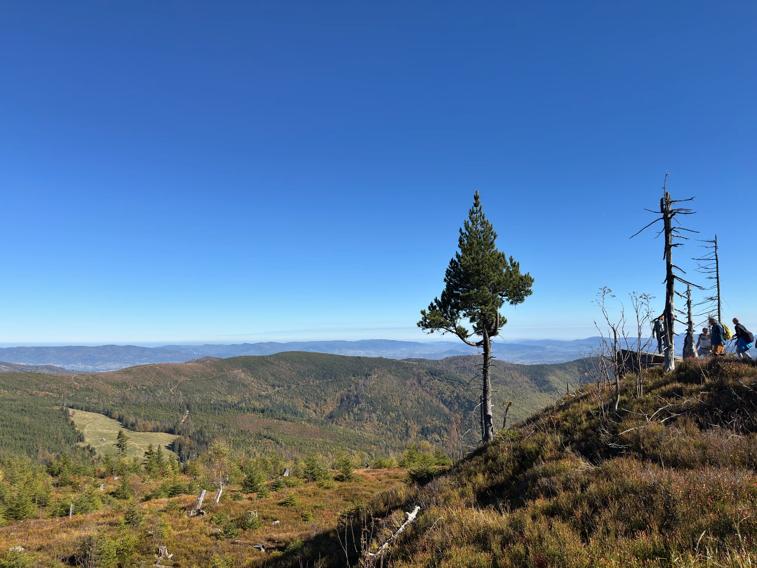
Barania Góra - trail from Wisła Czarne to the observation tower
Barania Góra is the second-highest peak of the Silesian Beskids and the place where the Vistula, Poland's longest river, begins. The Biała and Czarna Wisełka streams rise on its slopes, and the whole summit lies inside the Barania Góra Nature Reserve. In this article we take you on a loop from Wisła Czarne. The blue trail climbs along the Biała Wisełka and its many waterfalls, all the way to the observation tower on the summit. We also show you where to park and which other trails up Barania Góra are worth considering, from the shortest ascent from Kamesznica to a full-day route from Węgierska Górka. Let's go!
Table of contents:
Barania Góra
Barania Góra (1220 m) is the second-highest peak of the Silesian Beskids. Only Skrzyczne (1257 m) is higher. The massif has two summits: the higher main one, topped by the distinctive yellow observation tower, and the lower Wierch Wisełka (1190 m), a little to the south. What sets Barania Góra apart from other Beskid peaks are its slopes, where the Vistula, Poland's longest river, begins. Several well-marked trails lead to the top, among others from Wisła Czarne, Kamesznica and Węgierska Górka. The red Main Beskid Trail also runs over the summit, so Barania Góra is both a day-hike destination and a stop on a longer trek.
Barania Góra Nature Reserve
The upper parts of the massif are protected by the Barania Góra Nature Reserve, established in 1953. It covers the natural mountain mixed forest, which higher up turns into spruce forest, and the entire source area of the Vistula. The reserve is a refuge of the rare capercaillie, which has become a symbol of the place, and wolves, lynxes and bears also live in the surrounding forests. Lower down, along the Czarna and Biała Wisełka streams, lies a second reserve: the Wisła Nature Reserve.
Strict rules apply in the reserve: we stay on the marked trails, do not camp and do not leave the path to look for springs. An important note for dog owners: dogs are not allowed in the Barania Góra Reserve. The summit lies inside the reserve, so you cannot take a dog up Barania Góra on any trail. You can check the exact reserve boundaries on tourist maps by selecting it in the terrain options.
Sources of the Vistula
Many people come to Barania Góra to see the source of Poland's longest river, the Vistula. In reality there is no single source. The whole massif is a source area, and every stream and every trickle running down its slopes can count as the beginning of the river. The Vistula forms where two streams, the Czarna Wisełka and the Biała Wisełka, meet in Lake Czerniańskie. The Biała Wisełka owes its name to its light, rocky bed and foaming water. You can follow it along the first part of the route on the blue trail. The Czarna Wisełka flows over a darker bed.
The conventional sources of both streams lie off the trails, in the strictly protected part of the reserve, and nobody may approach them. That is why on 29 April 2026, a sign marking the symbolic source area of the Vistula was unveiled next to the blue trail from Wisła Czarne, at about 1100 m. We passed it on our hike.
Another attraction on the blue trail is the Kaskady Rodła: more than twenty natural rapids and waterfalls on the Biała Wisełka, the highest of them about 5 metres tall. You will pass these too on the blue trail.
PTTK mountain hut at Przysłop
There is no hut on the summit of Barania Góra. The nearest is the PTTK Przysłop pod Baranią Górą mountain hut, on the Przysłop clearing at about 950 m. It lies roughly 2.8 km from the summit, and the red and green trails lead to it. The current building dates from the 1970s. Earlier, from 1925 to 1979, the hut was housed in a wooden Habsburg hunting lodge. Right next door is the PTTK Mountain Tourism Museum, with souvenirs from the history of the Silesian Beskids. Our loop does not pass through Przysłop, but you can reach the hut on the blue-and-black variant described later in the article. For current accommodation offers and opening hours, see https://przyslop.pl/.
Observation tower on Barania Góra
The summit of Barania Góra is a broad plateau, and the trees on the western slope block part of the panorama. That is why in 1991, on the initiative of the Beskid Guides Club in Katowice, an observation tower was built here. This distinctive yellow steel structure is 15.2 m tall and weighs over 12 tonnes. Entry is free and possible all year round.
The tower has been through a difficult period. In April 2024 it was closed because of its poor technical condition, and for several months its future was in question. The PTTK branch in Wisła then took it over and, with support from the town, the Wisła Forest District and donors, carried out a thorough renovation: worn parts were replaced and the structure was protected against corrosion again. Since 27 September 2024 the tower has been open to visitors again. We first saw it before the renovation, in 2023. Now the tower has a stronger yellow colour, so you can see right away that it has been refreshed since then.
The effort of the climb really pays off, because the tower offers one of the finest panoramas in the Beskids. From here you can clearly see the Silesian Beskids and the Żywiec Beskids: among others Skrzyczne with its distinctive mast, Klimczok, Czantoria and Babia Góra. In good weather the Tatras and Malá Fatra also appear on the horizon.
Route options
There are plenty of route options up Barania Góra. In this article we describe in detail the loop from Wisła Czarne that we walked. Further on, together with maps, you will also find several other popular trails up Barania Góra: from the shortest ascent from Kamesznica to a full-day route from Węgierska Górka. There are a few longer options we did not cover, via Przysłop or in the opposite direction over Malinowska Skała. The routes:
from Wisła Czarne on the blue and yellow trails up Barania Góra - via Magurka Wiślańska back to Wisła Czarne (loop, our variant)
from Wisła Czarne on the blue trail up Barania Góra - the most popular variant
from Wisła Czarne on the blue and black trails up Barania Góra - descent via Przysłop and the black trail (loop)
from Kamesznica (Fajkówka) on the black trail - the shortest trail up Barania Góra
from Węgierska Górka on the red trail
Blue and yellow trail from Wisła Czarne - loop via Magurka Wiślańska
As usual we went for a loop, because we do not like coming back the same way. This variant shows you completely different sides of Barania Góra on a single route. Uphill we follow the blue trail through the Biała Wisełka valley, past the Kaskady Rodła and the symbolic sources of the Vistula, all the way to the observation tower on the summit. We return along the open, scenic ridge over Magurka Wiślańska (1140 m) and then on the quiet yellow trail.
Parking
Right at the start of the trail there is a small paid car park with a ticket machine. Parking costs 10 PLN per day. Car park coordinates: 49.620749, 18.945958. If it is full, a larger, unpaved free car park lies just under 700 m further on. Its coordinates are: 49.619600, 18.939067.
- Trail length:
- 18 km
- Duration:
- 5:45 h
- Elevation gain:
- 800 m
- Difficulty level:
- easy
Dogs are not allowed in the Barania Góra Reserve. You can find the exact area by clicking in the terrain options on tourist maps.
Trail description
From the car park mentioned above we set off on the blue trail, along an asphalt road that leads into the forest alongside the Biała Wisełka. This stretch runs for just under 3 km. On the way we pass many waterfalls and rock steps on the stream, and at the end of the asphalt we reach the Kaskady Rodła, a group of more than twenty natural waterfalls. They are one of the best things about this route. Then, following the signpost, we turn right and cross a small bridge onto a forest path.
From here the trail follows a fairly wide, pleasantly rising path through an autumn forest (we were here at the end of October). Over time the path narrows, gets stonier and in places climbs more steeply. The first views slowly start to appear between the thinning trees.
On the way we pass the sign marking the symbolic source area of the Vistula, unveiled in April 2026. It was put up so that hikers can get to know this place safely, without venturing into wild, protected habitats. You can read more about where the Vistula really begins in the Sources of the Vistula section. Further on the trail becomes quite narrow and reminded us of the path up Romanka. If you have not been there yet, take a look at our article about Romanka and Rysianka.
After about 4 km of forest road we reach a fork where a signpost sends us right and says the observation tower is only 10 minutes away. The terrain opens up more and more. A little further on we pass a distinctive rock outcrop, from which you can clearly see the mast on Skrzyczne and, a bit closer, the summit of Malinowska Skała. One last climb and the yellow, 15.2 m tall observation tower on Barania Góra rises in front of us. From its top you can clearly see the Silesian Beskids and the Żywiec Beskids, and in good weather also the Tatras and Malá Fatra.
From the summit we head back the way we came. At the fork this time we go straight on along the red and green trail, which traverses the slope of Barania Góra. We descend for a moment, only to climb again towards Magurka Wiślańska. The path on this stretch is largely exposed and stony. At the next fork we follow the green trail over the very top of Magurka.
At the following fork we turn onto the yellow trail. From here we start to descend, going deeper and deeper into dense forest. There are very few hikers on this stretch, and we met only a handful of people. At some point the trail reaches a wider road. We pass a food hut and a gazebo, where it gets busier, because quite a few people rest here on the grass over a meal.
We keep going on the yellow trail until we reach a small clearing, and what views it has! We take a last look at the mountains from above and walk back into dense forest.
The trail officially reaches an asphalt road and leads through Cieńków all the way to the main road towards the car park. Along the way, though, there are several shortcuts that cut the route and reduce the kilometres on asphalt. We took one of them, and a shorter way led us straight to the car park we had started from, closing the loop.
Summary of our route
The route is very pleasant and offers plenty of beautiful views. The loop makes the hike nicely varied. First comes an atmospheric climb along the Biała Wisełka with the Kaskady Rodła and the symbolic sources of the Vistula, then the panorama from the observation tower, the open ridge over Magurka Wiślańska, and finally a quiet descent on the yellow trail. You can also get pleasantly tired along the way. The whole thing took us less than 5 hours, including a breakfast break on the summit.
Blue trail from Wisła Czarne
One of the easier and most popular trails up Barania Góra. We go up and come back the same way, that is, on the blue trail through the Biała Wisełka valley, past the Kaskady Rodła and the sign marking the sources of the Vistula. The trail is not difficult, but it is not among the shortest either, which gives you more time to enjoy the views. There is a convenient car park before the start of the trail.
- Trail length:
- 14,8 km
- Duration:
- 4:45 h
- Elevation gain:
- 681 m
- Difficulty level:
- easy
Blue and black trail from Wisła Czarne via Przysłop
An interesting loop for anyone who wants to combine the ascent of Barania Góra with a visit to a mountain hut. We climb to the summit on the blue trail through the Biała Wisełka valley. We descend to the Przysłop clearing, where you can rest at the PTTK Przysłop pod Baranią Górą mountain hut. We return to Wisła Czarne through the Czarna Wisełka valley. A large part of this loop overlaps with the educational nature trail that runs through the valleys of both Wisełka streams, so the information boards along the way will teach you a lot about the local nature.
- Trail length:
- 18,2 km
- Duration:
- 5:40 h
- Elevation gain:
- 711 m
- Difficulty level:
- easy
Black trail from Kamesznica (Fajkówka)
The shortest and fastest trail up Barania Góra, approaching the massif from the east. A good choice if you are short on time but still want to stand on the summit and climb the observation tower. In Kamesznica, around Fajkówka, there are several small paid car parks.
- Trail length:
- 8,7 km
- Duration:
- 3:05 h
- Elevation gain:
- 509 m
- Difficulty level:
- easy
Red trail from Węgierska Górka
If you are planning a full-day hike, this is the trail to choose. The red Main Beskid Trail runs along it. It is neither the easiest nor the shortest, but that means long, unhurried enjoyment of beautiful mountain views on a quieter, less crowded trail. It will also tire you out properly! You walk the same route in both directions.
- Trail length:
- 24,4 km
- Duration:
- 8:13 h
- Elevation gain:
- 1206 m
- Difficulty level:
- medium
Frequently asked questions
How long does it take to walk up Barania Góra?
It depends on the trail you choose. The shortest ascent from Kamesznica is 8.7 km round trip and takes about 3 hours. The blue trail from Wisła Czarne (up and down the same way) is 14.8 km and takes about 4:45 h. According to the map, our loop via Magurka Wiślańska is 18 km and 5:45 h, but it took us less than 5 hours, including a breakfast break on the summit.
Can you take a dog up Barania Góra?
No. The summit lies within the Barania Góra Nature Reserve, where dogs are not allowed. This applies to all trails leading to the top. You can check the exact reserve boundaries on tourist maps by selecting it in the terrain options.
Where can you park in Wisła Czarne before hiking up Barania Góra?
Right at the start of the blue trail there is a small paid car park with a ticket machine: 10 PLN per day (49.620749, 18.945958). If it is full, a larger, unpaved free car park lies just under 700 m from it (49.619600, 18.939067).
Is the observation tower on Barania Góra open?
Yes. In April 2024 the tower was closed because of its poor technical condition, but after renovation it reopened to visitors on 27 September 2024. Entry is free and possible all year round. A maximum of 20 people may be on the tower at the same time, and climbing it is forbidden during a storm.
Where are the sources of the Vistula?
The whole Barania Góra massif is a source area of the Vistula, and the river forms where the Czarna and Biała Wisełka meet. The conventional sources of both streams lie off the trails, in the strictly protected part of the reserve, and nobody may approach them. Since April 2026 a sign has stood next to the blue trail from Wisła Czarne, at about 1100 m, marking the symbolic source area of the Vistula. We passed it on our loop.
And if you want to stay up to date with more travel inspirations, check out our socials!