
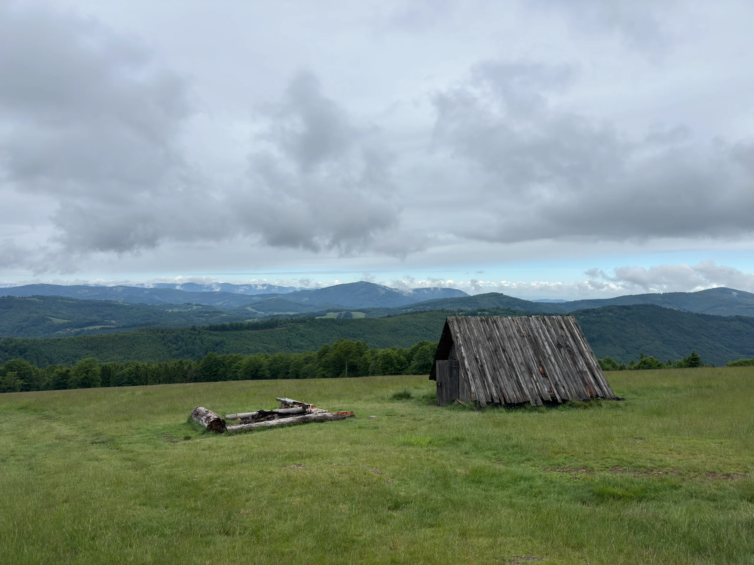
Kotarz - trail from Brenna via Hala Jaworowa
The Silesian Beskids are full of popular peaks and crowded trails, but sometimes it is worth choosing a less obvious direction. Kotarz via Hala Jaworowa is a proposal for those who value quiet hikes, forest paths and sweeping mountain panoramas. It is the scenic clearing on Hala Jaworowa that makes you want to stop for longer on the route, have a second breakfast and simply enjoy the Beskid landscape. In this article we describe the course of the trail, its variants and the most important information that will help you plan your trip.
Table of contents:
Kotarz
Kotarz (974 m a.s.l.) is one of the characteristic peaks of the Silesian Beskids, located in the Wiślańskie Range between the Salmopol Pass and the Karkoszczonka Pass. Although the summit itself is forested and does not offer wide views, the trails leading to it are very popular among hikers looking for quieter routes away from the most crowded Beskid peaks. Kotarz is also connected with one of the most beautiful clearings in this part of the Silesian Beskids, namely Hala Jaworowa. It stretches along the north-western ridge of the mountain and offers wide panoramas of the surrounding ranges. This is the place to stop for a longer rest and enjoy the views. There is no official mountain hut at the summit, but there is a cabin with food on offer - Piknik Bar. If you get hungry on the way down, there is also Chata Grabowa a bit lower.
Hala Jaworowa
Hala Jaworowa is a vast clearing located at an altitude of about 820-920 m a.s.l. in the Silesian Beskids. This place has a long shepherding history and for centuries was an important sheep-grazing area. Together with Stary Groń, it was one of the main centres of shepherding in Brenna. Grazing activity was still continued by a large sheepfold built in the lower part of the clearing, near the blue trail, but today there is no trace of this building left. Nevertheless, sheep still occasionally appear here in summer. The clearing is also a great viewpoint. A wide panorama of the Silesian Beskids stretches from here, with clearly visible Skrzyczne as well as the Stożek and Czantoria ranges. Further in the distance you can spot the peaks of the Moravian-Silesian Beskids.
Parking
We started our hike in the Hołcyna Valley, where we left the car in an unofficial parking spot along the road (coordinates: 49.705667, 18.926444). The spots are not marked, but if you arrive early enough, parking should not be a problem. On the day of our trip, cars were also parked parallel along the asphalt road.
If you plan to set off on a weekend or in peak tourist season, it is worth arriving a little earlier. Alternatively, you can leave your car in the centre of Brenna, where several car parks are available, though most are paid. Keep in mind, however, that such a choice will lengthen the route by an additional section along the asphalt road.
Route variants
Hołcyna Valley - Hala Jaworowa - Kotarz - Grabowa - Stary Groń - Brenna centre - Hołcyna Valley (longer loop with a stop at the viewing tower, but with longer asphalt sections)
Hołcyna Valley - Hala Jaworowa - Kotarz - return along the same route (the shortest option)
Hołcyna Valley - Hala Jaworowa - Kotarz - Grabowa - Utopiec Fairytale Trail (the variant described by us below)
Trail from the Hołcyna Valley via Kotarz and Grabowa
- Trail length:
- 11,5 km
- Duration:
- 4:19 h
- Elevation gain:
- 579 m
- Difficulty level:
- easy
- Dog-friendly trail:
- yes
Trail description
We start the route at the roadside parking in the Hołcyna Valley. The first section of the blue trail to Kotarz leads along an asphalt road gently climbing uphill through forest or sparse buildings.
After passing the last buildings, we unfold our trekking poles and step onto a forest path. From this moment the trail leads through typical mountain terrain. The ascent is not very demanding, which makes the route friendly even for less experienced hikers. For most of its length the trail is shaded by trees, which protects us from the sun on hot days. In time the narrow path turns into a wider, stony road leading to one of the most interesting places on the route, namely Hala Jaworowa. The last metres of the climb make your heart beat a little faster, but the effort is quickly rewarded. As soon as you reach the clearing, a wide panorama of the Silesian Beskids appears behind you.
During our hike the weather was not ideal, and for most of the time we were accompanied by clouds and passing rain. Even so, from time to time the surrounding peaks emerged from behind the clouds, including Skrzyczne, Czantoria and Wielki Stożek.
Skrzyczne - trails from Szczyrk, cable car and parking
The highest peak of the Silesian Beskids offering diverse hiking and cycling trails, as well as the possibility of using a cable car
Wielki Stożek - loop from Wisła Głębce and PTTK shelter
An easy and pleasant trail in the Silesian Beskids to kick off the spring mountain season. We present route variants and a detailed description of the shorter loop along the blue and red trails through Kiczory.
Hala Jaworowa itself is vast and completely exposed. There are spots prepared for campfires and a small wooden cabin. It is an ideal place for a short rest, a second breakfast or simply a moment spent admiring the mountain views. Then we continue along the worn path, which again plunges into the forest. Only a short section remains to the goal. After a few minutes we reach a junction of trails, where there is a small food point - Piknik Bar. On the left there is a gazebo with resting spots, and just behind it there is a sign marking the summit of Kotarz (974 m a.s.l.).
After a short stop and the obligatory photo, we head along the red trail towards the Salmopol Pass. At first the route is stony and quite steep, but after some time the incline softens. The trail leads mainly through forest, so the hike is pleasant even on warmer days. After about 20 minutes we reach Grabowa (907 m a.s.l.), from where we turn onto the black trail leading towards Stary Groń.
Further along the route we gradually leave the dense forest, and the first buildings begin to appear along the way. The next point on the route is Chata Grabowa, a popular stop for people hiking the Utopiec Fairytale Trail. You can use the food on offer here, and the youngest will surely be interested in the fairytale garden full of characters known from local legends and tales. We continue our descent along the black trail, passing several wooden sculptures referring to Beskid folklore. After less than 500 metres we reach a junction of trails, where next to the wooden figure of the devil Rokita we turn onto the red trail.
The further part of the route leads first along a wide forest road and then through open terrain. From this point the trail runs along an asphalt road, which we follow back to the Hołcyna Valley, closing the entire loop.
Utopiec Fairytale Trail
The Utopiec Fairytale Trail is a popular tourist route. The trail is about 8 km long and takes on average about 2 hours to walk. It is aimed primarily at families with children, although adults will also find many interesting places connected with local legends and the culture of the region.
The trail starts in the centre of Brenna, opposite the Municipal Office. However, if you prefer a shorter route and want to avoid the section along the roads, you can start your hike from the parking in the Hołcyna Valley, which we mentioned earlier.
The route leads through the picturesque Hołcyna Valley towards Chata Grabowa, where there is a unique Fairytale Garden. Along the way you will meet numerous wooden figures depicting characters known from Beskid tales and Slavic mythology. Viewpoints, educational boards and elements of an outdoor game have also been prepared along the trail to make the walk more varied for the youngest participants.
The first part of the route leads along an asphalt road, while the further section runs along forest paths and walking roads. Officially the trail ends in Brenna Leśnica, but returning from there involves a fairly long walk along the asphalt road. For this reason many people finish their trip at Chata Grabowa, where you can get the last stamp for the outdoor game and have a warm meal.
If you want to take part in the outdoor game, it is best to visit the Tourist Information in Brenna before starting your hike, where you will receive a card with tasks to complete while walking the trail.
It is a great proposal for families who want to encourage children to go on mountain hikes through play, discovering local legends and spending active time outdoors.
Route summary
Walking the entire route took us about 3 hours. The weather that day was quite unpredictable, so we met few hikers on the trail. Although the route itself leads through forest for most of the time and does not abound in numerous panoramas, the effort is rewarded by the views stretching from Hala Jaworowa, which is without doubt one of the most interesting points of the whole trip.
Those looking for a longer hike can extend the route to include Stary Groń, where there is a viewing tower offering additional panoramas of the Silesian Beskids. For families with children, the Utopiec Fairytale Trail will be a great addition. The route is easy and pleasant, and the numerous wooden sculptures depicting the heroes of local legends mean that the youngest will certainly not be bored.
Kotarz can be reached in many ways, both on a short walk and as a full-day trip across the surrounding peaks. Regardless of the chosen variant, it is a pleasant proposal for a quiet hike in the Silesian Beskids. And you, which variant would you choose for yourself?
Frequently asked questions
How high is Kotarz and how difficult is the hike?
Kotarz reaches 974 m in the Silesian Beskids' Wiślański Range, between the Salmopol and Karkoszczonka passes. It is an easy, quiet hike on forest paths. The summit itself is wooded with no wide views, so the scenic highlight is the Hala Jaworowa clearing on the way, where most people stop to rest.
Is Kotarz worth it if the summit has no views?
Yes. Although Kotarz's summit is forested and offers no broad views, the trip's highlight is Hala Jaworowa - a vast clearing at about 820-920 m with sweeping Silesian Beskids panoramas and a long shepherding history. For even more views, extend the walk to Stary Groń, where a viewing tower overlooks the range.
Where do you park for Kotarz?
We started in the Hołcyna Valley, parking in an unofficial roadside spot at 49.705667, 18.926444 - the spaces are not marked, but it is fine if you arrive early. Alternatively, park in the centre of Brenna, where several mostly paid lots are available, though that adds an asphalt section to the route.
Is there a family-friendly trail near Kotarz?
Yes. The Utopiec Fairytale Trail is a family route of about 8 km taking roughly 2 hours, lined with wooden figures from Beskid legends and Slavic mythology, plus viewpoints and an outdoor game. It starts in the centre of Brenna, though you can also join it from the Hołcyna Valley parking, and many finish at Chata Grabowa.
How long is the Kotarz hike?
Our route through Hala Jaworowa, Kotarz and Grabowa took about 3 hours. A popular loop of roughly 11.5 km (about 4:19) adds Grabowa, Stary Groń and its viewing tower before returning through Brenna. You can also go out and back to Kotarz for the shortest option, or continue on the Utopiec Fairytale Trail.
And if you want to stay up to date with more travel inspirations, check out our socials!