Jelenka Shelter from Malá Úpa - winter loop (with the possibility of ascending Śnieżka)
In this article, we'll take you on a very pleasant winter trail in the Karkonosze Mountains, which serves as both an ideal stop during the ascent to Śnieżka and a great point for creating interesting trekking loop variants. We visited this trail in winter when there was a really large amount of snow, which made the entire route exceptionally picturesque and atmospheric. However, it's worth remembering that in the summer season the trail may look completely different, which is worth keeping in mind when planning a trip there.
Table of contents:
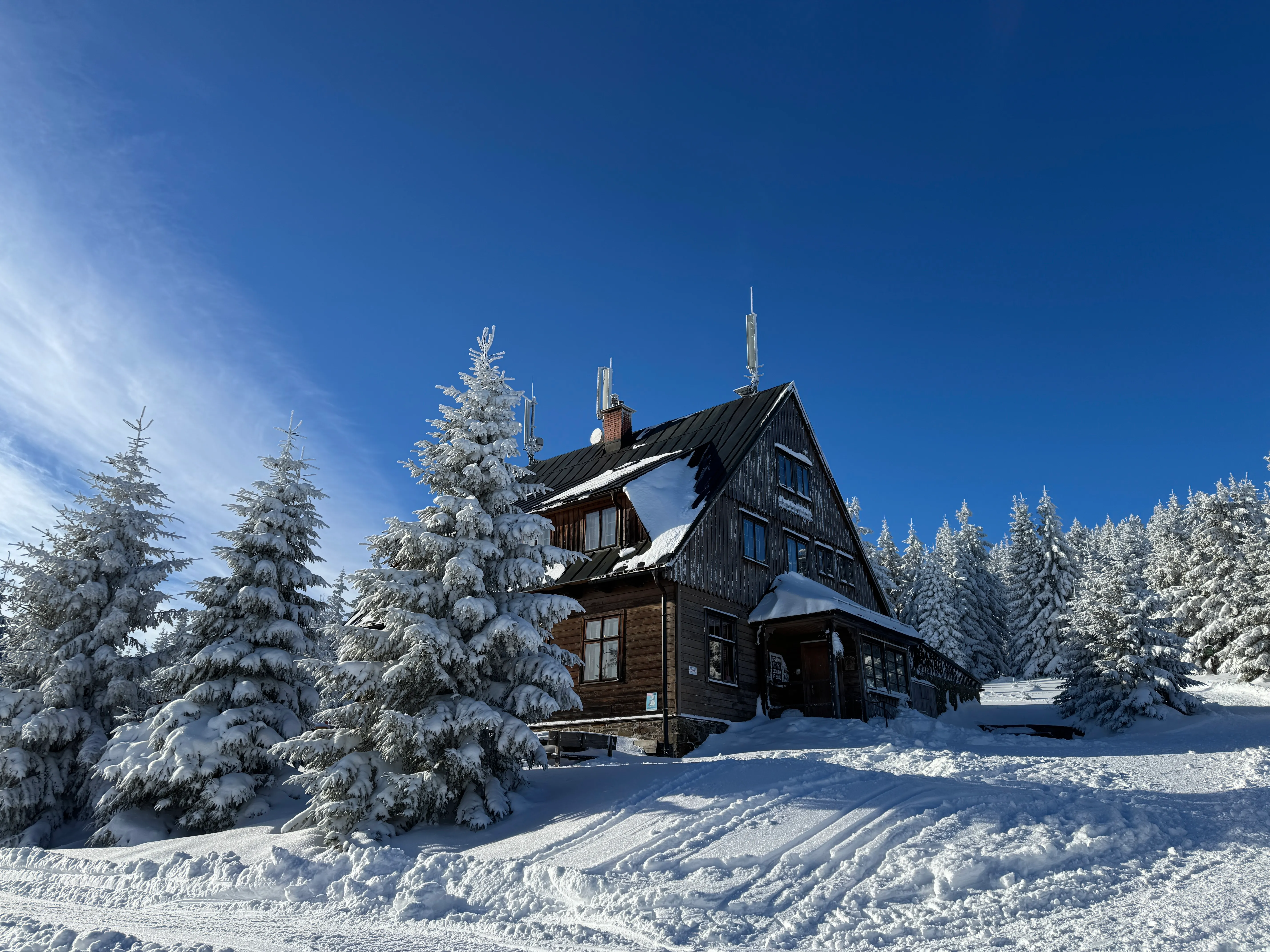
Bouda Jelenka Shelter
Jelenka Shelter is a small mountain refuge located at an altitude of 1260 m above sea level in the Karkonosze Mountains, on the Czech side of the border. It is a frequent stop during the trip to Śnieżka from Malá Úpa, but not only. Interesting hiking trails intersect at this point - the yellow one leading from Okraj Pass and the blue and red trails, slightly longer routes to Okraj Pass. Thanks to this, by visiting Jelenka shelter, you can plan several route variants - both short, scenic loops and longer hikes leading towards Śnieżka. We describe proposals for individual routes later in the article. The shelter operates all year round and offers a gastronomic point and accommodation, making it an excellent place to rest during both winter and summer hikes in the Karkonosze Mountains.
Horní Malá Úpa
Horní Malá Úpa is a small village on the Polish-Czech border, located at an altitude of about 1000 m above sea level, which is one of the winter recreation centers in this part of the Karkonosze Mountains. In Polish guides, you will often encounter the name Okraj Pass, located on the Polish side. Many hiking trails start from this place, both towards Śnieżka and to less frequented Karkonosze trails. There are also several ski slopes, which attracts a large number of winter sports fans. Accommodation, restaurants, small shops and a tourist information center are available on site, making it a convenient starting point for mountain hikes.
Parking
Parking lots are located on both the Polish and Czech sides, separated by only about 200 meters. On the Czech side, you can easily pay by card at the machine. The parking lot is located at these coordinates 50.746316, 15.823467. The parking cost is 150 CZK for the whole day or 50 CZK per hour. Parking on the Polish side costs 40 PLN for the whole day (prices current as of January 2026).
In winter, after heavy snowfall, there may be a problem with entering Horní Malá Úpa. There is a sign by the road informing that it is recommended to have snow chains. In our case, despite the winter season, the roads were well cleared, and since it hadn't snowed for several days, we managed to drive in without chains. However, it's worth paying attention to the conditions before you go there.
Route Variants
ascent and descent via the yellow trail - the simplest and fastest variant, ideal for a short trip or in worse weather conditions
loop through Jelenka - ascent via the yellow trail and descent via the red trail (variant described below) - a very pleasant and scenic route, allowing you to avoid returning the same way
loop through Jelenka and Skalny Stół - ascent via the yellow trail and descent via the blue trail - a more interesting and slightly longer option, ideal for those who want to diversify the route
route to Śnieżka via Jelenka Shelter - a good variant for those planning a further hike to the higher parts of the Karkonosze Mountains
At the end of the article you will find maps of the mentioned routes, which will make it easier to plan your trip.
Loop Through Jelenka
The loop through Jelenka is a very pleasant and scenic route, ideal for a short winter activity in the Karkonosze Mountains. The yellow trail leads from Horní Malá Úpa towards Jelenka shelter, while the return takes place via a slightly longer red trail, which brings us back to the starting village. Thanks to this, we don't return the same way, and the entire route creates an interesting and varied loop.
We managed to complete this variant in less than 2 hours, but it's worth noting that during our visit there were typical winter conditions. Despite sunny weather, the temperature dropped well below zero, so we maintained a fairly fast pace to avoid freezing. As we mentioned earlier, we visited this trail in winter when there was a large amount of snow in the Karkonosze Mountains, which made the route exceptionally picturesque. In winter, the trail looks completely different than in summer, so it's worth keeping this in mind when planning a trip at a different time of year. Let's move on to the trail itself.
Map
- Trail length:
- 7,2 km
- Duration:
- 2:30 h
- Elevation gain:
- 318 m
- Difficulty level:
- easy
Trail Description
Hiking this trail in winter conditions was exceptionally easy and pleasant. The path was clearly trampled in the snow, and in places so narrow that it was hard to pass other tourists. Thanks to this, even with a large amount of snow, orientation in the terrain did not cause any difficulties. The trail begins right at the main road in Horní Malá Úpa, where there is a clear signpost indicating the direction of the hike. The initial section leads between buildings, and at times the path runs very close to houses, almost under the very doors. After a while, the route widens briefly, only to narrow again to the width of one person. The further part of the route enters a coniferous forest covered with a thick layer of snow. This section is first almost flat, then gently descends.
After entering deeper into the forest, we reach a fork - the signpost informs that 1.5 km remains to Jelenka Shelter, and about 5 km to Śnieżka. From this moment the trail begins to climb clearly. The route leads along a wide, quite steep path all the time among the coniferous forest. Importantly, we cover most of this section completely alone, which makes a huge impression in the winter scenery of the Karkonosze Mountains. In the low temperature, we walk at a fairly fast pace and after a short time we reach the last turn, from behind which the shelter appears. It's worth turning around at this point to see the beautiful winter landscape emerging from among the trees.
At the shelter we take a short break for a moment of rest and warm tea. From here, about 3.3 km remain to Śnieżka, but this time we decide on a shorter route and choose to return via the red trail.
The return route is somewhat more frequented - we pass families with children and sleds and people moving on ski tours. The path is narrow and leads through the forest for a longer time. Initially, the trail descends quite steeply, then flattens out for a moment. We reach Owl Pass, where there is another fork - we still follow the markings of the red trail.
The last part of the route climbs uphill briefly, then leads downhill all the way to the end. The path gradually widens and leads us to the ski slope, from where only a short walk to the parking lot and the starting point of the hike remains
Safety
We went to this peak in winter, when we were greeted by a fairytale, snowy atmosphere. However, it's worth remembering that winter hikes in the mountains require proper preparation. First of all, before departure, you should check current trail conditions and road situation, especially before entering Okraj Pass - which we also mention in the parking section.
Proper layered clothing is key, and a hat, gloves and thick socks are absolute basics. During our winter expedition, crampons proved invaluable. They were especially useful on narrow and steep sections, where the path was trampled and packed, making it very slippery.
We definitely recommend bringing warm tea in a thermos - we guarantee that you will thank yourself for it on the trail.
Since the day is short in winter, even on a short route it's worth having a headlamp in your backpack. It may come in handy if you stay longer at the shelter and the return falls after dark.
Trail Maps
Loop Through Jelenka and Skalny Stół
Ascent via the yellow trail and descent via the blue trail - a more interesting and slightly longer option, ideal for those who want to diversify the route
- Trail length:
- 8,2 km
- Duration:
- 3:00 h
- Elevation gain:
- 379 m
- Difficulty level:
- easy
Route to Śnieżka via Jelenka Shelter
A good variant for those planning a further hike to the higher parts of the Karkonosze Mountains.
- Trail length:
- 14 km
- Duration:
- 5:14 h
- Elevation gain:
- 647 m
- Difficulty level:
- easy
Frequently asked questions
What is the Jelenka shelter and where is it?
Bouda Jelenka is a small mountain refuge at 1260 m in the Karkonosze, on the Czech side of the border. It is a frequent stop on the way to Śnieżka from Malá Úpa, where several trails cross - the yellow trail from Okraj Pass and the slightly longer blue and red routes. It serves warm food and drinks.
How long is the loop through Jelenka?
The loop starts in Horní Malá Úpa: the yellow trail climbs to the Jelenka shelter, and the red trail brings you back a slightly longer way, so you do not repeat the route. We completed it in under 2 hours, though in winter we kept a fast pace to stay warm. From the shelter it is about 3.3 km on to Śnieżka.
Where do you park for the Jelenka route?
There are car parks on both the Polish and Czech sides, about 200 m apart. The Czech lot (50.746316, 15.823467) takes card payment and costs 150 CZK per day or 50 CZK per hour; the Polish side is 40 PLN per day. After heavy snowfall, chains may be needed to reach Horní Malá Úpa.
Can you continue to Śnieżka from Jelenka?
Yes. Jelenka is a classic stop on the route to Śnieżka from Malá Úpa. From the shelter it is roughly 3.3 km to the summit, and a signpost earlier on the yellow trail shows about 5 km to Śnieżka from the forest fork. You can turn it into a longer loop or an out-and-back to the top.
What should I bring for the Jelenka trail in winter?
Winter hikes here need proper preparation. Wear layered clothing with a hat, gloves and thick socks, and pack crampons - they were invaluable on the narrow, packed, slippery sections. Bring warm tea in a thermos, and because winter days are short, carry a headlamp in case you return after dark.
And if you want to stay up to date with more travel inspirations, check out our Instagram!
@journeysjar