Wielki Stożek
In this article, to kick off the spring mountain season, we're taking you on an easy and pleasant trail in the Silesian Beskids leading to Wielki Stożek. We'll present several possible route variants and describe in detail the one we chose ourselves. It is less popular than the green trail, and at the same time very peaceful, which makes it a perfect idea for a pleasant morning hike in the mountains.
Table of contents:
Wielki Stożek
Wielki Stożek (978 m a.s.l.) is one of the peaks in the Stożek and Czantoria Range in the Silesian Beskids, located exactly on the Polish-Czech border. The summit lies between Stożek Mały and Kyrkawica, and is the third highest in this range, right after Wielka Czantoria and Kiczory. The entire massif is covered by dense forests - beeches and mixed forests dominate on the western side, while spruces prevail on the eastern side, which you'll see for yourself when choosing the blue trail. Thanks to this, the path leads in the shade most of the time, which is a great advantage especially on warmer days and in spring, when the trees are still leafless.
Most tourists come here from Wisła, but you can also reach it via the trail from Istebna or from the Czech Republic. Just below the summit there is the PTTK Stożek Shelter. It is a popular resting spot and an important point on the trail map, as routes leading towards Czantoria, Soszów, and Wisła cross here. Due to its position, Wielki Stożek seems to be a good option for admiring the sunrise, so we promise to check this and report back in the future!
Additionally, the Main Beskid Trail runs through Wielki Stożek, and the PTTK Stożek Shelter located just below the summit is one of the first overnight points on the route for people starting their hike in Ustroń.
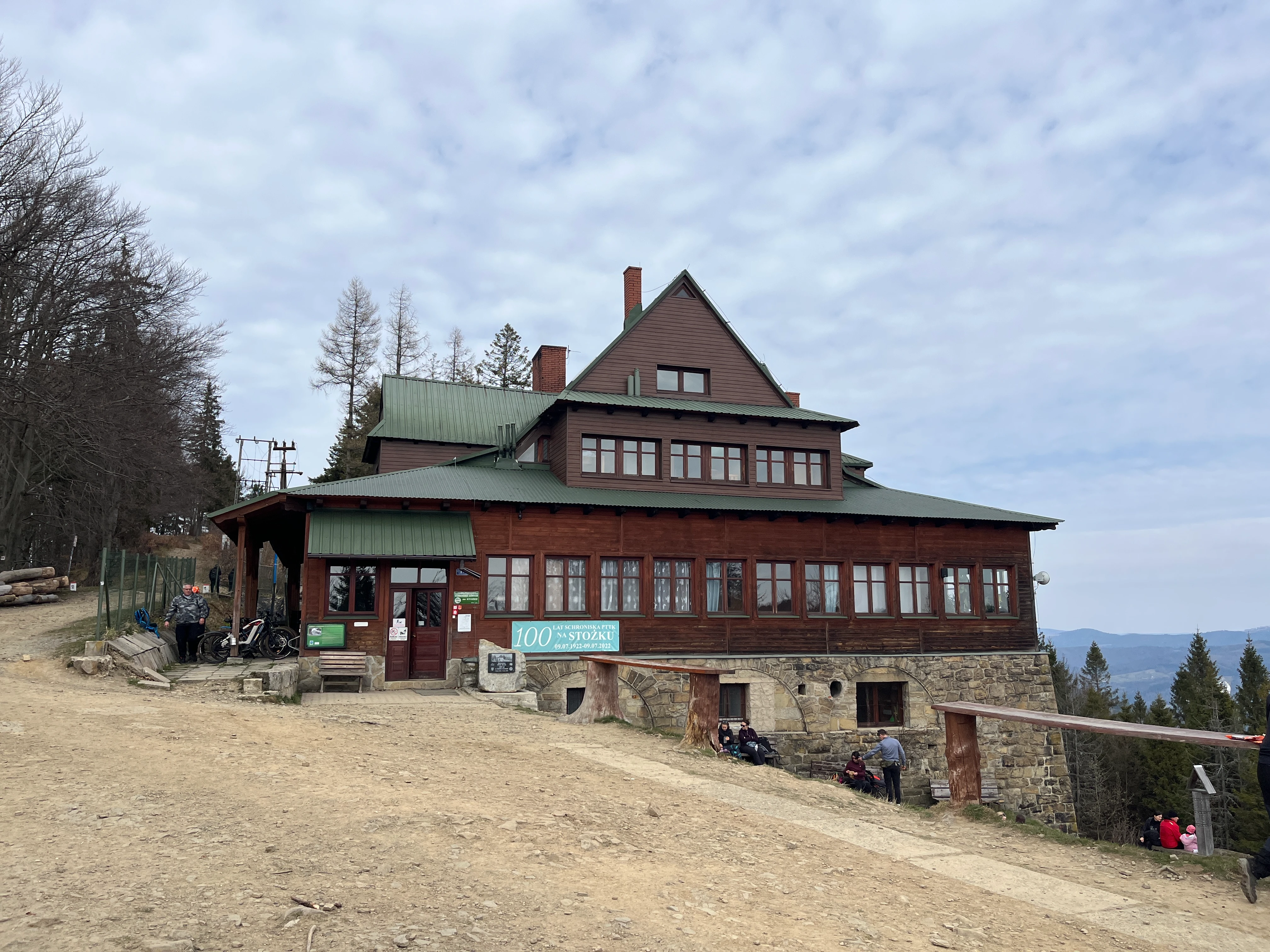
PTTK Stożek Shelter
The PTTK Stożek Shelter is located on the ridge by the Polish-Czech border, at an altitude of 957 m a.s.l. As we learned while preparing this article, it is the oldest shelter in the Silesian Beskids. It is a good place to take a break during the hike - you can have breakfast both inside and on the benches in front of the shelter, enjoying the mountain atmosphere. A full food and drink offer is also available on site. From the clearing in front of the shelter there is a view of the eastern part of the range, from where you can admire the peaks of the Silesian and Żywiec Beskids, and even the Tatras in good weather. The shelter also offers accommodation in various standards, with views of mountain landscapes. You will find detailed information, the current offer, and events on the official website: https://stozek.com.pl/
Route variants
Wielki Stożek can be reached in several ways, depending on how much time you have and what form of hiking you prefer. Below are the most popular options:
loop with ascent on green, descent on blue (the most popular option):
green trail from Wisła Głębce - PTTK Stożek Shelter - red trail through Kiczory - blue trail to Wisła Głębceshorter loop (the simplest option):
blue trail from Wisła Głębce - red trail to the PTTK Stożek Shelter - return on the red trail - blue trail to Wisła Głębceloop with descent through Kiczory:
blue trail from Wisła Głębce - red trail to the PTTK Stożek Shelter - descent on the red trail through Kiczory - blue trail to Wisła Głębce
Parking
No matter which trail you plan to take, they all start at one point - at the end of the road, 200m from the Wisła Głębce railway station. Starting from this point you skip the first quite steep ascent; however, if you're not arriving by train, be prepared for the fact that the parking lot by the station is not very large. The spaces are free and available to everyone, so many people heading out on the trail leave their car here (49.621474, 18.876081). There aren't many alternative parking lots in the area, even paid ones, so sometimes you have to look for a spot along the road or go back to the small parking lot by the Church of the Finding of the Holy Cross.
Trail
Shorter loop - blue and red trail
We decided on a fairly easy and pleasant trail to the shelter on Stożek via the blue trail, with a descent on a short section of the red trail through Kiczory, and then back onto the blue trail to the starting point.
- Trail length:
- 14,6 km
- Duration:
- 4:41 h
- Elevation gain:
- 590 m
- Difficulty level:
- easy
- Dog-friendly trail
Trail description
We start the trail at the aforementioned Wisła Głębce railway station. At the beginning, a short section of asphalt road awaits us, which gently rises uphill along the buildings. After a while, we reach the first marked fork - the road turning left leads to the blue trail, which we follow, while the path straight ahead is the green trail. For the next few dozen meters we still walk along the asphalt road, which after a while turns into a narrow route made of concrete slabs and leads us into the forest. After about 10 minutes we come across a marker directing us from the road to a forest path towards Łączecko Pass. Here the proper, slightly rocky trail begins. The route leads gently uphill and there aren't many steep ascents, although it can be muddy in places. Every now and then the forest thins out, revealing the first views. At one point the trail comes out again onto a concrete road near a few houses, then turns back into the forest. A little further on, we come across a small clearing on the right, from which we can see our hiking destination - Wielki Stożek.
After just under an hour, we reach Łączecko Pass, where the blue trail crosses the red one. Here we can continue along the blue trail or choose the red variant through Kiczory. We choose the second option and head straight along the path. Here the route becomes more muddy, and in some places there are remnants of snow. Coniferous trees dominate the forest, which makes the landscape more green, and the trail itself a bit more overgrown at times. After about 15 minutes we reach Kiczory (990 m a.s.l.), the highest point of this hike. From here we head further along the red trail, along the Polish-Czech border, until we reach the shelter on Stożek. It's worth stopping for a moment - the terrain is more open, so you can comfortably enjoy the views.
We set off on the way back along the same trail, but below Kyrkawica we turn onto the easy-to-miss blue trail. The path leads through the forest most of the time, but in some places the trees thin out, revealing beautiful views of the surrounding landscapes. At one point, after descending from the more forested section, a wide panorama of the nearby peaks opens up on the left. We reach Łączecko Pass again and, following the markings, head onto the blue trail, returning to the narrow path on which we earlier began our ascent. From here we follow the already familiar section all the way to the Wisła Głębce railway station, where we left the car.
Trail summary
We decided to climb to the summit via the blue trail, because the green trail runs for about 2 km along a fairly busy asphalt road. We try to avoid such sections, which is why we chose the variant leading entirely through the forest. This turned out to be a good choice, as during our April trip we didn't meet many tourists on the trail - more traffic only appeared near the shelter, where we ran into other hikers. Based on our observations, most people chose the green trail. Even though the blue variant runs largely through the forest, the route is very charming and pleasant. The lack of steep ascents makes it a good choice for starting the mountain season or for less experienced hikers.
Trail maps
Ascent on the green trail, descent on the blue trail
- Trail length:
- 12 km
- Duration:
- 4:09 h
- Elevation gain:
- 449 m
- Difficulty level:
- easy
Frequently asked questions
How high is Wielki Stożek and where is it?
Wielki Stożek rises to 978 m in the Stożek and Czantoria Range, right on the Polish-Czech border. It is the third highest peak in the range, after Wielka Czantoria and Kiczory, and the whole massif is cloaked in beech and spruce forest. The Main Beskid Trail runs across it.
How long is the hike and which trail is best?
Most people climb from Wisła, though trails also come from Istebna and the Czech side. We took an easy blue-and-red forest loop of roughly 12-14.6 km, about 4 to 4.5 hours. We chose the blue trail over the green one, which runs about 2 km along a busy asphalt road, and it is a much quieter, more pleasant option.
Where do you park for Wielki Stożek?
All the trails start from the same point - the end of the road about 200 m from the Wisła Głębce railway station. The spaces are free and open to everyone, but the lot is not large, so it fills up in season. Starting here also lets you skip the first steep ascent.
Is there a mountain shelter on Wielki Stożek?
Yes. The PTTK Stożek Shelter sits on the ridge at 957 m, just below the summit on the Polish-Czech border, and is the oldest shelter in the Silesian Beskids. It serves a full food and drink menu, with seating inside and on benches out front, and is one of the first overnight stops on the Main Beskid Trail from Ustroń.
Can you hike Wielki Stożek with a dog?
Yes, the blue-and-red loop to Wielki Stożek is a dog-friendly trail. It leads almost entirely through forest, is not very demanding and passes the PTTK Stożek Shelter, which makes it a comfortable outing to do with a dog.
And if you want to stay up to date with more travel inspirations, check out our Instagram!
@journeysjar