
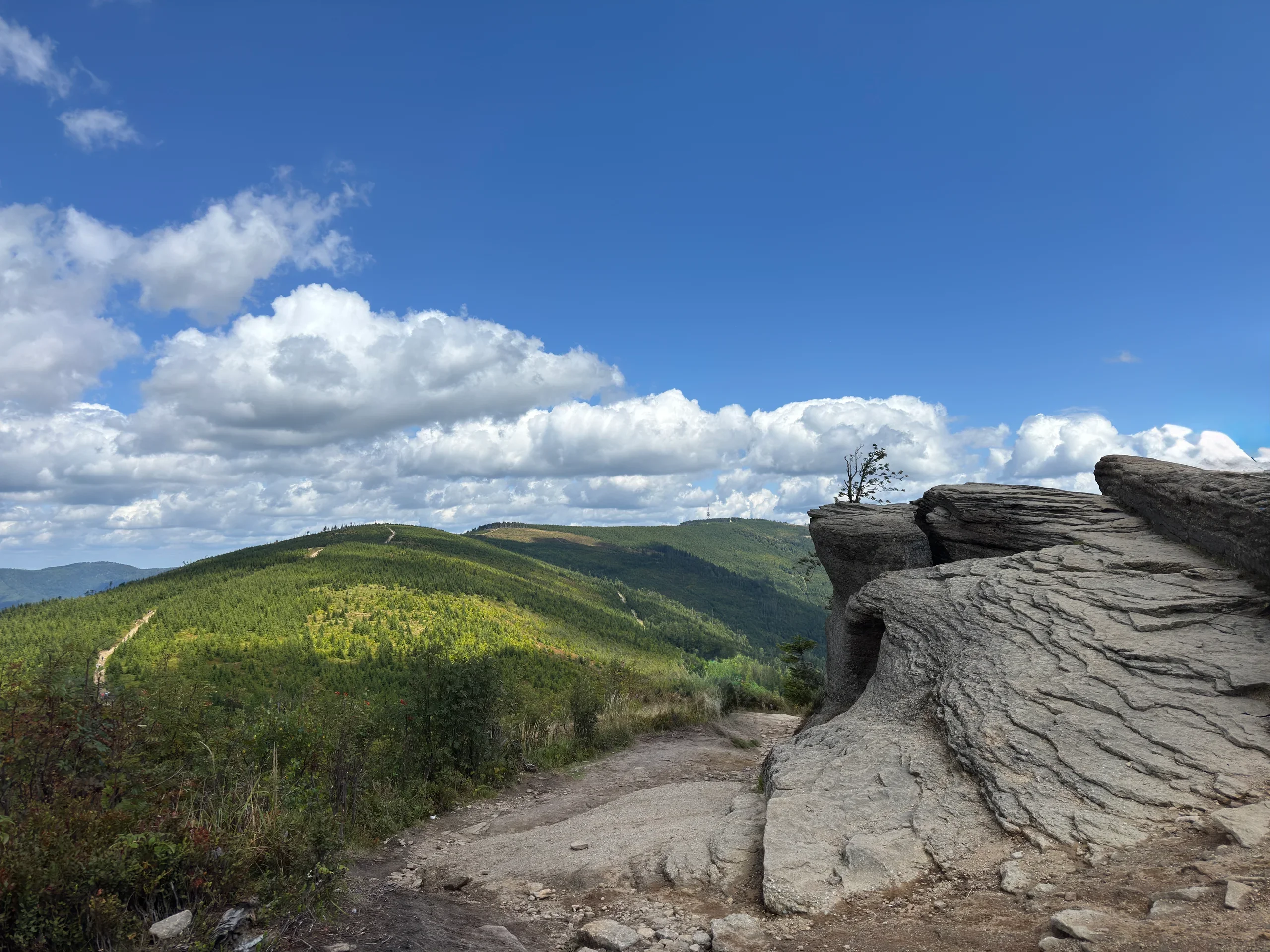
Malinowska Skała - trail from Biały Krzyż and a loop from Lipowa via Skrzyczne
Several trails lead to Malinowska Skała in the Silesian Beskids, so you can choose between a short hike from Biały Krzyż and a longer route that links it with Skrzyczne. We walked both, so in this post you will find detailed trail descriptions, parking information and our experience of hiking to Malinowska Skała, including at sunrise. Enjoy the read!
Table of contents:
Malinowska Skała - where it is and what to know
Malinowska Skała is one of the most distinctive peaks of the Silesian Beskids, at an elevation of 1152 m a.s.l. It sits on the ridge connecting the areas of Skrzyczne and Barania Góra, so you can reach it by several trails and combine the ascent with a longer hike through the Silesian Beskids.
The most recognizable feature of Malinowska Skała is, of course, the distinctive rock outcrop. It lies a few metres from the summit marker and is definitely worth the short walk, because it makes a great viewpoint.
We have come back to Malinowska Skała more than once. We have walked both the short red trail from Biały Krzyż and the longer route linking it with Skrzyczne. We also headed up early in the morning to see the sunrise. We tell you about all of these trips here.
Malinowska Cave
One of the more interesting attractions near Malinowska Skała is Malinowska Cave, which you can reach by a detour from the red trail leading from Salmopolska Pass. It is not a typical karst cave. It formed when rock masses cracked and shifted, so inside you will find mostly narrow crevices and rough rock corridors. The whole system is about 230 metres long, and entering requires a headlamp, suitable footwear and clothing, because inside it is cold, wet and muddy in places.
The cave is set up for visitors, with metal ladders at the entrance. Keep in mind that it is closed from October to April so that the bats hibernating inside are not disturbed. If you are heading to Malinowska Skała in summer and fancy an extra attraction, it is worth planning time for this short detour from the main trail.
Sunrise on Malinowska Skała
Malinowska Skała is one of the more rewarding peaks of the Silesian Beskids for a morning outing. The open eastern side of the summit makes it a great spot to watch the sun come up. If you are planning a night hike, choose the shortest red trail so you reach the top quickly. It is worth arriving at least 30 minutes before the planned sunrise, because the real show of colours in the sky begins then.
In our opinion autumn is the best time for such a trip. First, for plain comfort, because sunrise comes much later than in June. Second, in autumn you are more likely to catch an inversion, a phenomenon in which fog fills the valleys and the summit stays above it. That is when the photos turn out best.
The whole climb leads through forest, so a headlamp is a must from the first metre to the last. We will not hide that Malinowska Skała is a popular place to watch the sun wake up, so there can be quite a few people. We have to admit that the first time we went, it comforted us a little that we would not be climbing through that dark forest alone.
Temperature inversion
Look for a high-pressure system (above 1020 hPa), a windless, clear night and a large temperature difference between day and night. The simplest test: check the forecast temperature in the morning in the valley and at the summit. If it is supposed to be warmer higher up than down below, that is an inversion and there is a good chance of fog. Still, conditions can sometimes change just before we set off and not everything can be predicted. It has happened to us too.
Trails to Malinowska Skała - route options
Several trails lead to Malinowska Skała, so you can adjust the route to your abilities and the time you want to spend in the mountains:
The red trail from Biały Krzyż, that is Salmopolska Pass - the shortest option, described by us in this article,
The blue trail from Solisko in Szczyrk,
The yellow trail from Lipowa,
The loop from Lipowa via Skrzyczne and Malinowska Skała - a variant that links both peaks into one longer route - also described below
Red trail from Biały Krzyż (Salmopolska Pass)
The most popular and also the shortest trail to Malinowska Skała starts at Salmopolska Pass, also called Biały Krzyż. The route is relatively short and pleasant, so it works well both for a relaxed mountain outing and for sunrise. On the way it is worth making a detour towards Malinowska Cave, because its entrance is not far from the trail.
Parking at Salmopolska Pass
The parking is right by the trail, next to the inn at Salmopolska Pass. The inn's own car park is quite large, but paid. On the right-hand side of the road there is a small but free car park, which fills up very quickly because of its popularity. Coordinates of the parking, which is also the starting point of the route: 49.6644856, 18.9603961.
- Trail length:
- 7,6 km
- Duration:
- 2:34 h
- Elevation gain:
- 444 m
- Difficulty level:
- easy
- Dog-friendly trail:
- yes
Trail description
The route starts at Biały Krzyż on Salmopolska Pass, at an elevation of 934 m a.s.l. From the very beginning the trail is well marked and leads uphill. At first the climb is fairly steep and stony, but over time the route eases off. This part of the trail is quite densely forested.
After reaching Malinowska Pass the trail descends slightly. Here the terrain opens up a little and the first views appear. This is also where you can make the detour towards Malinowska Cave. Tall deciduous trees give way to lower conifers.
After crossing the pass the trail starts to climb again. A forest section follows, and about 30 minutes of a stony, wider path remain to the destination. When the forest starts to thin out again, you know you are getting close to the summit.
Once you reach the summit area, it is worth not ending the hike at the Malinowska Skała marker itself. Just walk a few metres further to see the distinctive rock outcrop that gave the peak its name.
Summary of our route
We have walked this trail more than once, both during the day and early in the morning, when we came here for the sunrise. The route is very pleasant and charming, and its short length makes Malinowska Skała a good choice also when you do not feel like a full-day hike.
If you have more time, it is worth combining it with other peaks of the Silesian Beskids and turning the hike into a longer loop.
Loop from Lipowa via Skrzyczne to Malinowska Skała
If you fancy a longer hike, we recommend the loop from Lipowa, which links two popular peaks of the Silesian Beskids: Skrzyczne (1257 m a.s.l.), the highest peak of the Silesian Beskids, and Malinowska Skała. The route runs largely along an open ridge, so besides a solid climb it guarantees plenty of views.
Parking in Lipowa
We leave the car at the free and spacious car park in Lipowa (49.6666730, 19.0758115). Because the trails to popular Skrzyczne and Malinowska Skała start from here, the spaces fill up quickly, so it is worth arriving early enough.
- Trail length:
- 15,7 km
- Duration:
- 5:14 h
- Elevation gain:
- 801 m
- Difficulty level:
- easy
- Dog-friendly trail:
- yes
Trail description
We started the loop with the steep climb so that we could return by the gentler route, so from the car park in Lipowa we set off on the blue trail to Skrzyczne. It is about 1.5 hours of hard climbing, because over 4 km you gain as much as 726 m of elevation. Walking along the car park we head for the trail, which begins at a junction where after about 100 m it turns left into the forest and climbs steeply. Because we were here on one of the summer weekends, quite a few other hikers were already heading the same way. The trail leads mostly through forest, in places along a stony path.
Only on the last stretch does the forest thin out, the first views appear and the terrain starts to level off. When we step out onto open ground almost free of trees, we know the goal is near, and at the summit the RTV transmitter mast already rises in front of us. At the mountain hut on Skrzyczne we take a short breakfast break.
Next we set off on the green trail towards Malinowska Skała. This section is more exposed and much busier, because hikers move along here between the cable car to Skrzyczne and the cable car at Zbójnicka Kopa. After passing the upper station of the cable car on Zbójnicka Kopa the crowd clearly thins out. The trail continues over Little Skrzyczne (1211 m a.s.l.).
The whole 4 km from the hut to Malinowska Skała is a scenic, gentle route, mostly almost flat, with one tougher climb just before the rock itself. A wonderful panorama opens up here over the Żywiec Basin and the surrounding peaks, among others Barania Góra, further on Babia Góra and Pilsko and, with good visibility, even the Tatras. It is worth taking a longer break here and walking a few metres to the distinctive rock outcrop.
From Malinowska Skała we continue on the green trail towards the descent, and at the fork we switch to the yellow trail. Most of the route here leads through forest, but it is a bit more exposed to the sun than the ascent. The trail is much gentler, although a large part of it is stony. The last 1.5 km follows an asphalt road to the car park itself. The descent should not take you more than 2 hours, unless you stop often to pick wild blackberries and blueberries.
Summary of our route
Our hike took 4 hours and 22 minutes, and the watch showed 16.4 km and 828 m of elevation gain. We set off on a warm Saturday morning. Between Skrzyczne and Malinowska Skała we met quite a lot of people, but the descent was quiet, and in places we walked completely alone. If you want to avoid the crowd on the ridge, choose a weekday or an early morning.
Frequently asked questions
How long does it take to climb Malinowska Skała?
By the shortest route, the red trail from Biały Krzyż, about 1.5 hours (3.7 km). The loop from Lipowa via Skrzyczne takes 4-6 hours.
Where to park for Malinowska Skała?
At Salmopolska Pass there is a paid car park by the inn and a small, free car park on the right-hand side of the road, which fills up quickly (49.6644856, 18.9603961). In Lipowa there is a large, free car park, where the loop via Skrzyczne starts (49.6666730, 19.0758115).
Is there a mountain hut on Malinowska Skała?
No. The nearest hut is on Skrzyczne, and at Salmopolska Pass (Biały Krzyż) there is an inn.
Can you climb Malinowska Skała in winter?
Yes, the short trail from Biały Krzyż also works outside the summer season. Remember a headlamp, microspikes and the short day, though. The only thing you will miss is Malinowska Cave, which is closed in winter.
How do you get from Skrzyczne to Malinowska Skała?
By the green trail, about 4 km along the ridge via Zbójnicka Kopa and Little Skrzyczne. The section is scenic and mostly flat, with one tougher climb right before the rock.
What is Biały Krzyż?
It is the colloquial name of Salmopolska Pass (934 m a.s.l.), the most popular starting point for Malinowska Skała.
When is the best time for a sunrise on Malinowska Skała?
In our opinion autumn is best, because sunrise comes much later then than in summer, and inversions are also more common in autumn, meaning situations where fog fills the valleys and the summit stays above it.
And if you want to stay up to date with more travel inspirations, check out our socials!