Mannen (400 m a.s.l.)
Welcome to Lofoten! If you haven't read our practical guide about the archipelago yet, we recommend checking it out as you'll find lots of tips for planning your trip and trekking. Here, however, we'll focus on the Mannen peak (400 m above sea level). We'll convince you why this not very high, but spectacular peak, located right next to the famous Haukland beach, is a must-visit during your stay in Lofoten.
Lofoty - guide
Part I - practical guide to the Norwegian archipelago - transport, accommodation, and advice on preparing for travel!
Table of contents:
Mannen
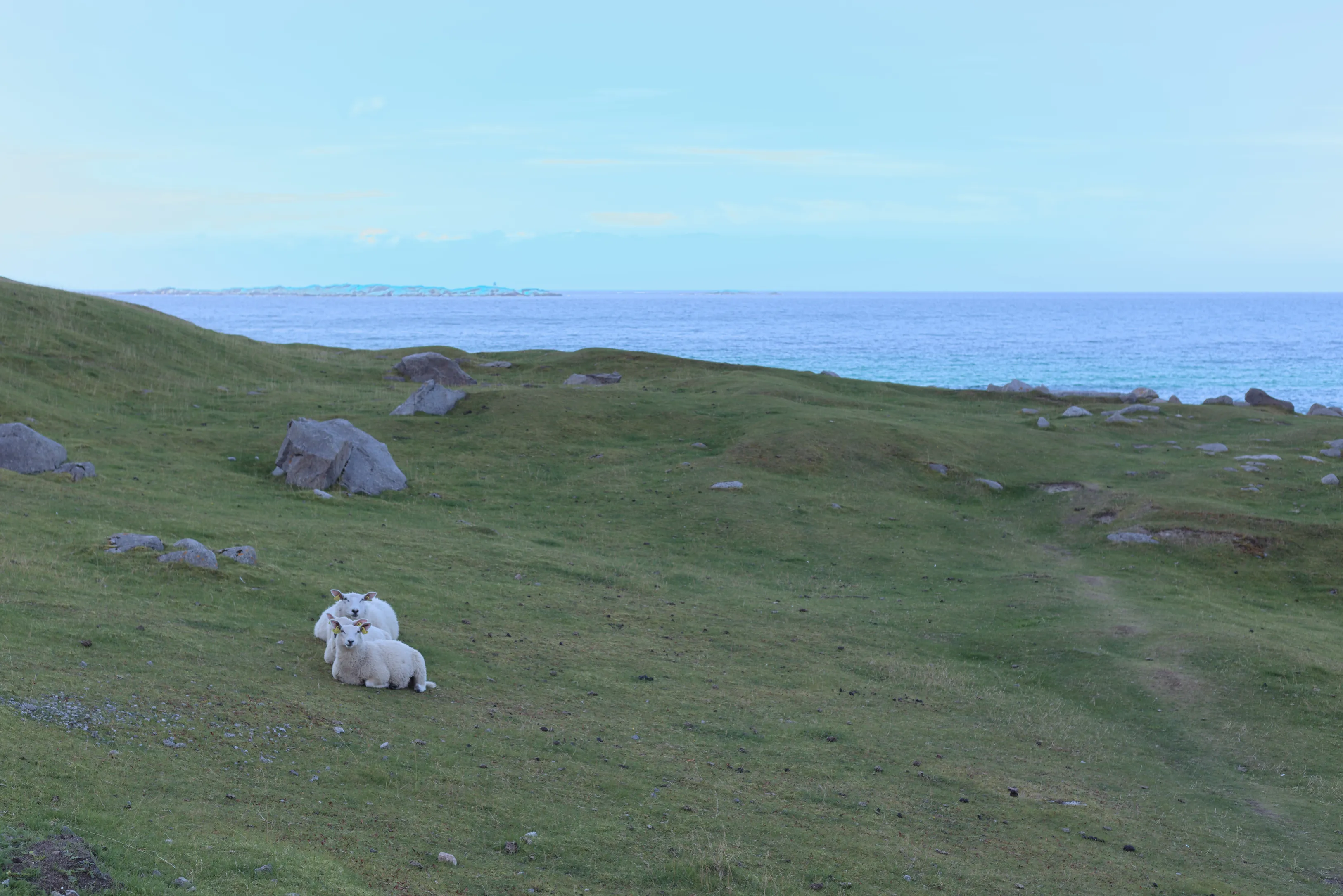
Mannen is one of the more popular peaks in Lofoten, primarily because it's relatively easy and pleasant to climb, while the views from the summit are truly breathtaking. By the way, if you decide to do the loop (which we recommend), you'll visit two beautiful sandy beaches and vast sheep pastures. The peak is located on Vestvågøy island and has an elevation of 400 m above sea level. Right next to it rises the neighboring Veggen (489 m above sea level), higher but already much more demanding. Mannen is surrounded by two extraordinary beaches: Hauklandstranda (link to our article) and Uttakleivstranda (link to our article). From the summit you can also spot a third beach Vik (link to our article), along which campers often park. Around Veggen runs a wide, comfortable path along the sea, connecting Haukland with Uttakleiv. This is a great way to combine mountain trekking with a coastal walk and create a truly diverse trip. Mannen is an excellent choice for starting your adventure with Lofoten peaks, as the trail is neither long nor very demanding, and the final effect is truly spectacular.
Trail variants
Trail variants:
Uttakleiv - Mannen - Uttakleiv - if you don't decide to do the loop, we recommend this section next
Haukland - Mannen - Haukland
Uttakleiv - Mannen - Haukland - Uttakleiv (loop)
Haukland beach
Uttakleiv beach
Loop through two beaches and Mannen
We'll present you with the loop variant, because in our opinion it's worth visiting both beaches and taking a walk around Veggen along the coast.
- Trail length:
- 9.9 km
- Duration:
- 3:00 h
- Elevation gain:
- 370 m
- Difficulty level:
- easy
Parking
There are two options depending on which trail variant you choose and which beach you want to start from. At Haukland beach there's a fairly spacious paid parking (via Easy Park app) 68.199373, 13.532745. Next to it is a café and free toilets. The second option is to park on the other side of Mannen, i.e., at Uttakleiv beach 68.209594, 13.504978. Here the fee is charged through the car's license plate number. A camera reads the vehicle upon entry and exit and depending on the parking time calculates the fee, which later needs to be settled on the YouPark website. There's also a camping site at the parking.
Parking at Haukland beach
Trail description
We started the trail from Haukland beach. Right from the parking you pass through a special gate that's meant to prevent sheep from escaping, and immediately the ascent begins. The trail is not marked at any stage, so you should follow the worn paths. The asphalt ends very quickly, and the further path leads steeply, sometimes slaloming uphill. After a short time we reach a fork, where the path to the right leads to Uttakleiv beach, while we turn in the opposite direction towards the summit. From this moment the route consistently climbs uphill. Sometimes the ascent is steeper, but doesn't require any climbing skills. Throughout the journey we're accompanied by views of the turquoise Hauklandstranda beach and the surrounding peaks. Along the way you can often meet flocks of sheep peacefully grazing on steep slopes. The route is completely exposed, so it can be quite windy at the summit.
View of Haukland beach
Path to Mannen summit
From Mannen summit spreads a spectacular panorama of Lofoten peaks rising from the water and stretching deep into the archipelago, as well as wonderful cream-colored beaches. Depending on the time of day and season, the views present themselves in different magnificent forms. During our ascent clouds had gathered, but during the descent the sky cleared again.
View from Mannen
We started the descent on the same route we climbed, until the fork, where this time we turned left towards Uttakleiv. The path leads between two peaks, and after a moment the view of the beach we're heading towards emerges. Already from above you can see wide, green pastures covered with dozens of sheep. The descent is gentle and pleasant, leading all the way to a gate, beyond which the grazing area ends. From there you exit onto a road that leads straight to the beach parking. You can go down to the beach itself or continue walking along the coast on the path connecting Uttakleiv with Haukland. This section is about 4 km and is almost completely flat, making it quick and very pleasant to walk (well, unless you stop at a wild little beach or for photos along the way, which we recommend). Finally, the familiar view of the white Haukland beach and blue sea in the background emerges again.
Uttakleiv beach
Uttakleiv beach
Area around Uttakleiv beach
Pastures before Uttakleiv
Path around Veggen
Small beach along the path
Seasonality
Mannen is considered a year-round peak. The best conditions for climbing it will be in the period from May to September, especially during peak season, i.e., from June to July, when the days are longest and you can admire the setting sun from it without fear of descending in the dark. However, during the winter period the ascent is possible if weather conditions allow. It's worth then ensuring appropriate equipment, as the trail can be slippery and icy.
Frequently asked questions
How long is the Mannen loop and how difficult is it?
Mannen is an easy peak. The full loop taking in both beaches is about 9.9 km with roughly 370 m of elevation gain and takes around 3 hours. The trail is unmarked, so you follow worn paths, and it is completely exposed - expect wind at the summit - but it needs no climbing skills.
Where do you park for Mannen?
You can start from either beach. Haukland has a spacious paid lot (Easy Park app) at 68.199373, 13.532745, with a cafe and free toilets next to it. Uttakleiv, on the other side of Mannen, has a lot at 68.209594, 13.504978 charged by license plate via YouPark, plus a campsite.
How high is Mannen and which beaches surround it?
Mannen is 400 m above sea level, on Vestvagoy island, right between Haukland and Uttakleiv beaches; from the top you can also spot a third beach, Vik. Its neighbour Veggen (489 m) is higher but much more demanding. A flat coastal path of about 4 km links Uttakleiv back to Haukland.
Is Mannen a good peak for beginners?
Yes. Mannen is one of the best peaks to start your Lofoten adventure - the trail is short, not very demanding and needs no climbing skills, while the summit views are spectacular. The ascent is steep in places and unmarked, so follow the worn paths and take care on the exposed, windy top.
When is the best time to climb Mannen?
Mannen is a year-round peak. The best conditions are from May to September, and especially June to July, when days are longest and you can watch the sunset from the top without descending in the dark. Winter ascents are possible when the weather allows, but the trail can be slippery and icy, so bring proper equipment.
And if you want to stay up to date with more travel inspirations, check out our Instagram!
@journeysjar