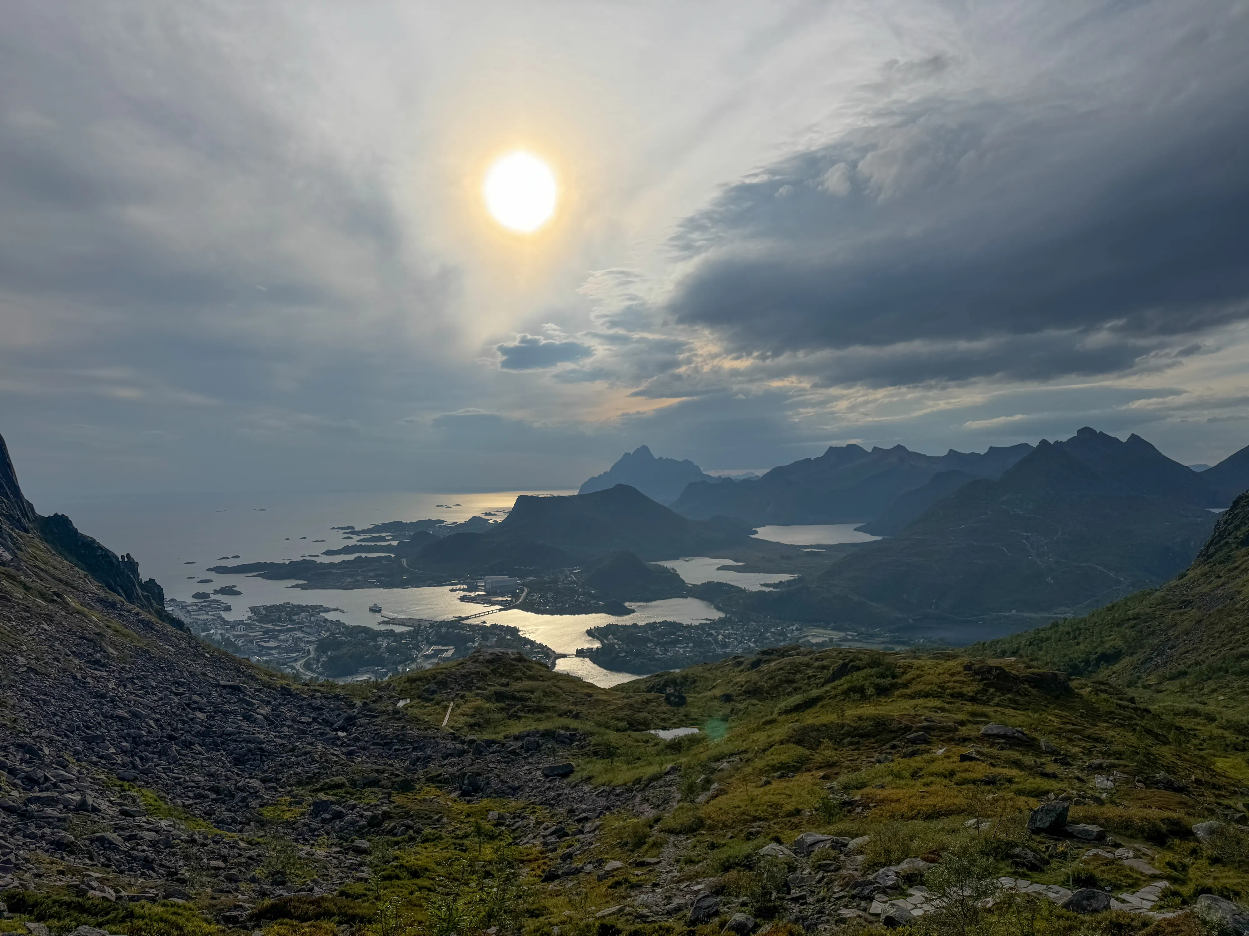
Djevelporten (440 m a.s.l.)
Djevelporten (the Devil's Gate) is a natural rock bridge above Svolvær in Lofoten - one of the archipelago's most spectacular viewpoints. The trail is just 3 km but steep: 429 m of elevation gain and 505 stone steps at the start. The hike takes about 1.5 hours one way, best from May to September.
If you haven't read our practical guide about the archipelago yet, we recommend checking it out - you'll find plenty of tips for planning your trip and trekking. Here, we'll take you to one of the more popular viewpoints in Svolvær.
Lofoty - guide
Part I - practical guide to the Norwegian archipelago - transport, accommodation, and advice on preparing for travel!
Table of contents:
Djevelporten
Djevelporten, literally translated as "The Devil's Gate", is one of the most recognizable attractions near Svolvær (link to our article) in Lofoten. It's a distinctive stone wedged between two rock walls, creating a natural bridge, making it an ideal spot for spectacular photos, but only for those without a fear of heights. This formation is located on the trail leading to the summit of Fløya (590 m above sea level). From this point, there's an impressive view of Svolvær, nearby islands, and fjords. The trail to Djevelporten is one of the most popular trekking routes in this part of the archipelago, as it's relatively short, but steep and at times requires good fitness. Nevertheless, it's definitely worth the visit. Various guidebooks give slightly different heights for the formation itself, but from the map we can read that it's approximately 440 - 450 m above sea level.
Trail to Djevelporten
- Trail length:
- 3 km
- Duration:
- 1:36 h
- Elevation gain:
- 429 m
- Difficulty level:
- medium
Parking
Right at the trail entrance, there's a fairly large paid parking lot 68.244769, 14.577822. You can pay through the Easy Park app. There's another paid parking lot a bit further 68.242705, 14.570815.
Trail Description
The route starts right by the parking lot and from the very beginning leads through stone steps that were laid by Nepalese Sherpas. As the sign at the entrance informs, there are 505 steps to climb. After this section, the trail changes into a more natural path, with wooden walkways in places or large rocks smoothed by tourists. Here, good trekking boots are mandatory, as the stones can be slippery, especially after rain. As you gain altitude, a magnificent panorama of Svolvær and the surrounding islands increasingly unfolds. The trail is marked in places, and the ascent is quite steep most of the time, so a bit of fitness will be helpful. The last section leads through steps again, though it's shorter and ends at a small rocky plateau where you can rest and enjoy the view. On one side stretches the landscape of the city and fjords, on the other you can see a distinctive rock shelf suspended above an abyss. However, you should remember that the gap between the rocks is often very windy, so it's worth being cautious.
Trail markings
Smoothed rocks on the trail
Last ascent before Djevelporten
Rock shelf at Djevelporten
Viewpoint
Seasonality
The trail is accessible mainly in the summer season, from May to September, when weather conditions allow for safe entry. That's when the paths are free from snow and ice, and temperatures favor trekking. In the winter period (from November to March), the trail is not recommended. In this season, snow often lies on the ground, and the stone steps are covered with ice. Access to Djevelporten can be dangerous without crampons and winter equipment, so local services and guidebooks advise against taking the route without experience in winter conditions.
Frequently asked questions
How long does the hike to Djevelporten take?
The hike to Djevelporten takes about 1.5 hours one way. The trail is roughly 3 km with 429 m of elevation gain. Although short, it's steep - it starts with 505 stone steps, so basic fitness helps.
Is the Djevelporten trail difficult?
The trail is moderately difficult. It begins with 505 stone steps and then follows a natural, sometimes slippery path, so good trekking boots are essential. The ascent is steep for most of the route but requires no climbing gear.
Where can you park for Djevelporten?
There's a large paid parking lot right at the trail entrance (68.244769, 14.577822), payable via the EasyPark app. A second paid lot is a little further away (68.242705, 14.570815).
When is the best time to hike Djevelporten?
The best time is the summer season, from May to September, when the paths are free of snow and ice. In winter (November-March) the trail is not recommended - the stone steps are icy and, without crampons and winter experience, the approach can be dangerous.
What is Djevelporten (the Devil's Gate rock bridge)?
Djevelporten, the Devil's Gate, is a distinctive boulder wedged between two rock walls, forming a natural bridge. It sits on the trail to the Fløya summit above Svolvær, at about 440-450 m above sea level, and is one of the most popular photo spots in Lofoten.
And if you want to stay up to date with more travel inspirations, check out our Instagram!
@journeysjar