Wielka Rycerzowa
Wielka Rycerzowa - a peak located in Beskid Żywiecki at an altitude of 1226 m above sea level. It's a great place for the mountain hut and camping base located there. No wonder, as the meadow below the summit provides a good viewpoint for mountain panorama. Below the hut there are special places for campfires, benches and access to water. There's also a volleyball court and several hammocks. In this article we will present two route variants to the summit.
Table of contents:
Wielka Rycerzowa
A charming hill belonging to the Wielka Racza group in Beskid Żywiecko-Kisucki. From the summit you can continue to other trails including the nearby Przegibek, or further to Wielka Racza. At the foot of the summit there is a meadow at Przełęcz Halna, from which there is a wonderful panorama of the Tatras. With good visibility you can also see Wielka Racza, Przegibek pass, some peaks of Mała Fatra and Babia Góra. In front of the beginning forest belt lies a small mountain hut that offers accommodation, as well as the possibility of pitching a tent in its area. A bit higher up the hut we found a bench for second breakfast with a view of the Tatra peaks. Seasonally, a volleyball net, hammocks and benches appear on the hut grounds. A bit lower there's also a place for a campfire. During this hike we made a quite pleasant loop going up the yellow trail and returning via the black one.
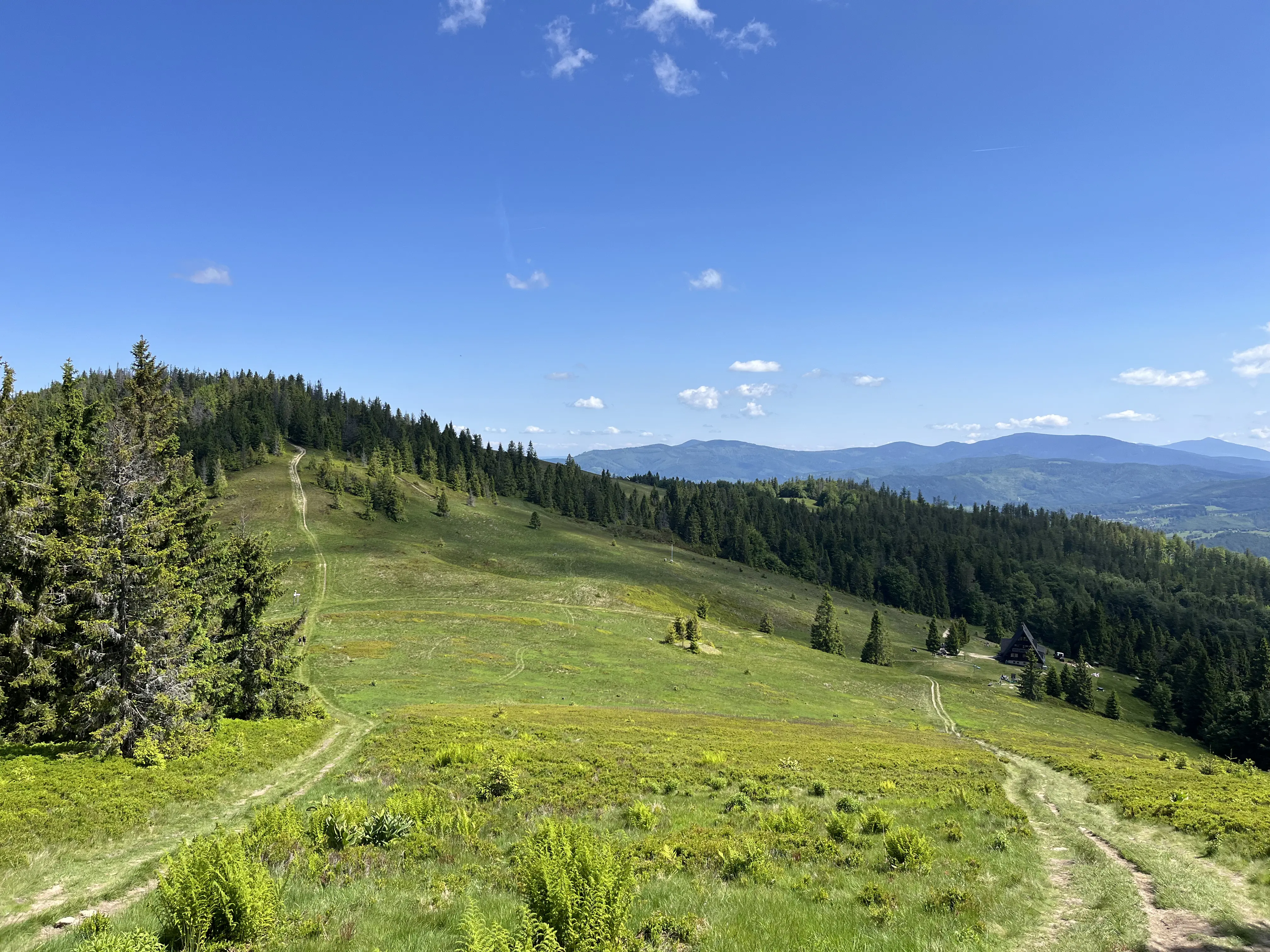
Przełęcz Halna pass
PTTK hut on Rycerzowa
Przełęcz Halna pass
Benches at Przełęcz Halna
Parking
If you are going on the yellow or black trail and starting from the town of Soblówka you can use the free parking: 49.4371731, 19.1424483. There are quite a lot of spaces, and with a large number of cars you can drive a bit further where there are also places to leave your vehicle.
Yellow trail to the hut on Rycerzowa
- Trail length:
- 5,3 km
- Duration:
- 2:20 h
- Elevation gain:
- 600 m
- Difficulty level:
- easy
Trail description
The first proposal is to start the expedition with the yellow trail from the free parking (given above) in the town of Soblówka. Directly in front of the small church there is immediately an entrance to the rocky trail. After just a dozen meters of hiking the route forks. The Szlaki.pl app led along the asphalt road, but we went down according to the signs on the rocky road. Initially it was pleasant to walk on the laid-out route of wooden logs, until the trail turned into thickets. We had to wander around for a while before we got back to the proper route. Later we followed the yellow trail uphill without problems. A large part of the route leads through an exposed path which is worth taking into account when planning to go there during midday hours. At the intersection with the green trail the road again leads through the forest. The paths are mostly wide and rocky. There are quite a lot of steep ascents but it's pleasant to walk. At the fork of the trails it's worth going down to the green trail to pass through Hala Rycerzowa, where there is a meadow with a beautiful panorama of the Tatras and other surrounding peaks. There is also a mountain hut on the meadow. You can also continue along the yellow trail bypassing the ascent to the meadow. Both these roads connect at Przełęcz Halna, where there is also a mountain hut. Then there remains a short but quite steep ascent to the summit. At the information sign the views are obscured by trees, so to enjoy the panorama it's best to go back to the small meadow.
Hala Rycerzowa meadow
Yellow trail section
To descend you can go down the same way or descend via the black trail to make a loop. We chose to return via a different route.
Return via black trail
To make a loop, from the mountain hut you need to return again to the yellow and black trail. Before Hala Rycerzowa the road forks and there we follow only the black trail. Here there are also many exposed spaces where there is no shade. For the last 1.5 km of the route we reach the first buildings and the beginning of the asphalt road, which leads through the forest and along the Cicha river leads all the way to the parking lot.
- Trail length:
- 6,3 km
- Duration:
- 1:44 h
- Elevation gain:
- 595 m
- Difficulty level:
- easy
Loop summary
We managed to cover the entire route with breaks in 3.5 hours and did 12 km. The loop was very pleasant, only the last section on asphalt dragged on a bit. Due to the fact that a large part of the route runs through exposed spaces we advise not to climb there around midday hours. Despite the warm June weekend it wasn't too crowded on the trail. In our opinion it's worth visiting Wielka Rycerzowa especially for the views from the top.
Frequently asked questions
How high is Wielka Rycerzowa and what is at the top?
Wielka Rycerzowa reaches 1226 m in Beskid Żywiecki, within the Wielka Racza group. Just below the summit, on Przełęcz Halna, a meadow opens a wonderful panorama - on a clear day you can see the Tatras and Wielka Racza. There is a mountain hut and camping base with fire pits, benches, water and even a volleyball court.
How long is the Wielka Rycerzowa loop and how hard is it?
From Soblówka the yellow trail leads up to the hut - about 5.3 km with 600 m of ascent, roughly 2:20 - and you can loop back down the black trail. We did the whole loop in 3.5 hours over 12 km. It is rated easy, though large parts are exposed with no shade and the last 1.5 km run along asphalt.
Where do you park for Wielka Rycerzowa?
If you take the yellow or black trail from Soblówka, use the free parking lot at 49.4371731, 19.1424483. There are plenty of spaces, and when it is busy you can drive a little further, where there are more places to leave the car.
Can you stay overnight or camp at Wielka Rycerzowa?
Yes. There is a mountain hut just below the summit that also serves as a camping base. Below the hut you will find designated fire pits, benches, access to water and a volleyball court, making the meadow a comfortable spot to rest or pitch a tent with a mountain panorama.
Any tips for hiking Wielka Rycerzowa?
Because a large part of the route runs across exposed, shadeless meadows, avoid climbing around midday in warm weather. Even on a warm June weekend it was not too crowded. The only slightly tedious part is the final 1.5 km on asphalt, but overall it is a pleasant, easy loop worth doing.
And if you want to stay up to date with more travel inspirations, check out our Instagram!
@journeysjar